
Carte topographique Braunlage
Carte interactive
Cliquez sur la carte pour afficher l’altitude.
À propos de cette carte
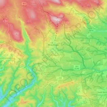
Nom : Carte topographique Braunlage, altitude, relief.
Lieu : Braunlage, Landkreis Goslar, Lower Saxony, Germany (51.65043 10.49042 51.78087 10.68399)
Altitude moyenne : 617 m
Altitude minimum : 365 m
Altitude maximum : 967 m
Braunlage is located on the Warme Bode, a headstream of the river Bode, close to the border with Elend in the state of Saxony-Anhalt. The municipal area stretches along the south-eastern rim of the Harz National Park from an elevation of 550 m (1,800 ft) up to 971 m (3,186 ft) at the summit of the Wurmberg. Other peaks in the vicinity include the Achtermannshöhe and the Hahnenklee Crags.
Autres cartes topographiques
Cliquez sur une carte pour visualiser sa topographie, son altitude et son relief.
Goslar
Germany > Lower Saxony > Landkreis Goslar
Goslar, Landkreis Goslar, Lower Saxony, Germany
Altitude moyenne : 312 m
Hohegeiß
Germany > Lower Saxony > Landkreis Goslar > Braunlage
Hohegeiß, Braunlage, Landkreis Goslar, Lower Saxony, Germany
Altitude moyenne : 568 m
Sankt Andreasberg
Germany > Lower Saxony > Landkreis Goslar > Braunlage
Sankt Andreasberg, Braunlage, Landkreis Goslar, Lower Saxony, Germany
Altitude moyenne : 648 m
Altenau
Germany > Lower Saxony > Landkreis Goslar > Clausthal-Zellerfeld
Altenau, Altenau - Schulenberg i.O., Clausthal-Zellerfeld, Landkreis Goslar, Lower Saxony, Germany
Altitude moyenne : 599 m
Lochtum
Germany > Lower Saxony > Landkreis Goslar > Goslar
Lochtum, Goslar, Landkreis Goslar, Lower Saxony, Germany
Altitude moyenne : 196 m
Langelsheim (Innenstadt)
Germany > Lower Saxony > Landkreis Goslar > Langelsheim (Innenstadt)
Langelsheim (Innenstadt), Langelsheim, Landkreis Goslar, Lower Saxony, 38685, Germany
Altitude moyenne : 257 m