
Carte topographique Fence
Cliquez sur la carte pour afficher l’altitude.
À propos de cette carte
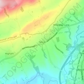
Nom : Carte topographique Fence, altitude, relief.
Altitude moyenne : 187 m
Altitude minimum : 83 m
Altitude maximum : 404 m
Autres cartes topographiques
Cliquez sur une carte pour visualiser sa topographie, son altitude et son relief.
Colne Water
United Kingdom > England > Lancashire > Borough of Pendle > Laneshaw Bridge
Altitude moyenne : 202 m
Colne
United Kingdom > England > Lancashire > Borough of Pendle
Pendle Leisure Trust runs the Pendle Leisure Centre next to the railway station. The facility has two swimming pools, a fitness centre and gymnasium, sauna and sports hall. In summer 2013, the outdoor all-weather pitch was replaced by Urban Altitude. This outdoor aerial assault course is the first of its kind…
Altitude moyenne : 197 m
Laneshaw Bridge
United Kingdom > England > Lancashire > Borough of Pendle > Laneshaw Bridge
Altitude moyenne : 269 m
Barrowford
United Kingdom > England > Lancashire > Borough of Pendle > Barrowford
Altitude moyenne : 161 m
Barnoldswick
United Kingdom > England > Lancashire > Borough of Pendle > Salterforth
Altitude moyenne : 175 m
Colne
United Kingdom > England > Lancashire > Borough of Pendle
Pendle Leisure Trust runs the Pendle Leisure Centre next to the railway station. The facility has two swimming pools, a fitness centre and gymnasium, sauna and sports hall. In summer 2013, the outdoor all-weather pitch was replaced by Urban Altitude. This outdoor aerial assault course is the first of its kind…
Altitude moyenne : 197 m
Barnoldswick
United Kingdom > England > Lancashire > Borough of Pendle > Salterforth
Altitude moyenne : 175 m