
Carte topographique Province of Víctor Fajardo
Carte interactive
Cliquez sur la carte pour afficher l’altitude.
À propos de cette carte
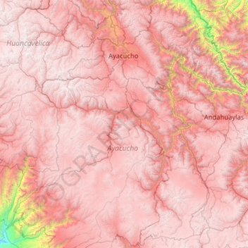
Nom : Carte topographique Province of Víctor Fajardo, altitude, relief.
Lieu : Province of Víctor Fajardo, Ayacucho, Peru (-14.71181 -75.21780 -12.71181 -73.21780)
Altitude moyenne : 3 598 m
Altitude minimum : 268 m
Altitude maximum : 5 235 m
Autres cartes topographiques
Cliquez sur une carte pour visualiser sa topographie, son altitude et son relief.
Poma
Peru > Ayacucho > Querobamba
Poma, Querobamba, Province of Sucre, Ayacucho, Peru
Altitude moyenne : 3 482 m
Chicha
Peru > Ayacucho > San Pedro de Larcay > Chicha
Chicha, San Pedro de Larcay, Province of Sucre, Ayacucho, Peru
Altitude moyenne : 3 540 m
Coronel Portillo
Peru > Ayacucho > Canayre > Coronel Portillo
Coronel Portillo, Canayre, Province of Huanta, Ayacucho, Peru
Altitude moyenne : 704 m