
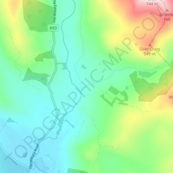
Carte topographique Blacklunans
Carte interactive
Cliquez sur la carte pour afficher l’altitude.
À propos de cette carte
Nom : Carte topographique Blacklunans, altitude, relief.
Altitude moyenne : 357 m
Altitude minimum : 241 m
Altitude maximum : 655 m
Autres cartes topographiques
Cliquez sur une carte pour visualiser sa topographie, son altitude et son relief.
Coupar Angus
United Kingdom > Scotland > Perth and Kinross
Coupar Angus, Perth and Kinross, Scotland, PH13 9DA, United Kingdom
Altitude moyenne : 70 m
Perth
United Kingdom > Scotland > Perth and Kinross
Perth, Perth and Kinross, Scotland, PH1 5SU, United Kingdom
Altitude moyenne : 131 m
Crieff
United Kingdom > Scotland > Perth and Kinross
Crieff, Perth and Kinross, Scotland, PH7 3BS, United Kingdom
Altitude moyenne : 115 m
Forgandenny
United Kingdom > Scotland > Perth and Kinross
Forgandenny, Perth and Kinross, Scotland, PH2 9EQ, United Kingdom
Altitude moyenne : 53 m
Blairgowrie and Rattray
United Kingdom > Scotland > Perth and Kinross > Blairgowrie and Rattray
Blairgowrie and Rattray, Perth and Kinross, Scotland, PH10 6AB, United Kingdom
Altitude moyenne : 121 m
Kindallachan
United Kingdom > Scotland > Perth and Kinross
Kindallachan, Perth and Kinross, Scotland, PH9 0NW, United Kingdom
Altitude moyenne : 162 m