
Carte topographique Union County
Carte interactive
Cliquez sur la carte pour afficher l’altitude.
À propos de cette carte
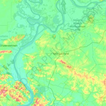
Nom : Carte topographique Union County, altitude, relief.
Lieu : Union County, Kentucky, United States (37.46977 -88.16019 37.90171 -87.73458)
Altitude moyenne : 122 m
Altitude minimum : 97 m
Altitude maximum : 237 m
Autres cartes topographiques
Cliquez sur une carte pour visualiser sa topographie, son altitude et son relief.
Louisville
United States > Kentucky > Jefferson County > Louisville
Louisville, Jefferson County, Kentucky, 40202-2923, United States
Altitude moyenne : 180 m
Lexington
United States > Kentucky > Lexington
Lexington, Fayette County, Kentucky, 40508, United States
Altitude moyenne : 285 m
Vanceburg
United States > Kentucky > Lewis County
Vanceburg, Lewis County, Kentucky, 41179, United States
Altitude moyenne : 226 m
Orchard Grass Hills
United States > Kentucky > Oldham County
Orchard Grass Hills, Oldham County, Kentucky, United States
Altitude moyenne : 214 m
Murray
United States > Kentucky > Calloway County
Murray, Calloway County, Kentucky, United States
Altitude moyenne : 159 m
East Bernstadt
United States > Kentucky > Laurel County
East Bernstadt, Laurel County, Kentucky, United States
Altitude moyenne : 367 m
Sandhill
United States > Kentucky > Muhlenberg County
Sandhill, Muhlenberg County, Kentucky, 42369, United States
Altitude moyenne : 143 m
McDowell
United States > Kentucky > Floyd County
McDowell, Floyd County, Kentucky, 41647, United States
Altitude moyenne : 324 m
Indian Hills Cherokee Section
United States > Kentucky > Jefferson County > Indian Hills
Indian Hills Cherokee Section, Indian Hills, Jefferson County, Kentucky, 40207, United States
Altitude moyenne : 168 m
Morning View
United States > Kentucky > Kenton County
Morning View, Kenton County, Kentucky, 41063, United States
Altitude moyenne : 192 m
Broad Bottom
United States > Kentucky > Pike County
Broad Bottom, Pike County, Kentucky, 41659, United States
Altitude moyenne : 274 m
Plumville
United States > Kentucky > Mason County
Plumville, Mason County, Kentucky, United States
Altitude moyenne : 247 m
Lawrence County
Lawrence County, Kentucky, United States
Altitude moyenne : 255 m
Carrollton
United States > Kentucky > Carroll County
Carrollton, Carroll County, Kentucky, United States
Altitude moyenne : 170 m
Livingston County
Livingston County, Kentucky, United States
Altitude moyenne : 131 m
Keaton
United States > Kentucky > Johnson County
Keaton, Johnson County, Kentucky, 41226, United States
Altitude moyenne : 270 m
Owensboro
United States > Kentucky > Daviess County
Owensboro, Daviess County, Kentucky, United States
Altitude moyenne : 123 m
Elizabethtown
United States > Kentucky > Hardin County
Elizabethtown, Hardin County, Kentucky, 42701, United States
Altitude moyenne : 241 m
Aboretum
United States > Kentucky > Calloway County > Murray
Aboretum, Murray, Calloway County, Kentucky, United States
Altitude moyenne : 168 m
Edsel
United States > Kentucky > Elliott County
Edsel, Elliott County, Kentucky, United States
Altitude moyenne : 277 m
Dunmor
United States > Kentucky > Muhlenberg County
Dunmor, Muhlenberg County, Kentucky, 42339, United States
Altitude moyenne : 179 m
Muhlenberg County
Muhlenberg County, Kentucky, United States
Altitude moyenne : 144 m
Villa Hills
United States > Kentucky > Kenton County
Villa Hills, Kenton County, Kentucky, United States
Altitude moyenne : 224 m
Oak Grove
United States > Kentucky > Christian County
Oak Grove, Christian County, Kentucky, 42262, United States
Altitude moyenne : 170 m
Burtonville
United States > Kentucky > Lewis County
Burtonville, Lewis County, Kentucky, United States
Altitude moyenne : 254 m
Buster Hill
United States > Kentucky > Wayne County > Monticello
Buster Hill, Monticello, Wayne County, Kentucky, 42633, United States
Altitude moyenne : 295 m
Limp
United States > Kentucky > Hardin County
Limp, Hardin County, Kentucky, United States
Altitude moyenne : 211 m
Danville
United States > Kentucky > Boyle County
Danville, Boyle County, Kentucky, United States
Altitude moyenne : 290 m
Hindman
United States > Kentucky > Knott County
Hindman, Knott County, Kentucky, United States
Altitude moyenne : 388 m
E.P. "Tom" Sawyer State Park
United States > Kentucky > Jefferson County > Louisville > Lakeland
E.P. "Tom" Sawyer State Park, Lakeland, Louisville, Jefferson County, Kentucky, United States
Altitude moyenne : 209 m
Lebanon Junction
United States > Kentucky > Bullitt County
Lebanon Junction, Bullitt County, Kentucky, United States
Altitude moyenne : 144 m
Gilbertsville
United States > Kentucky > Marshall County
Gilbertsville, Marshall County, Kentucky, United States
Altitude moyenne : 104 m
Clark County
Clark County, Kentucky, 40391, United States
Altitude moyenne : 273 m
Morehead
United States > Kentucky > Rowan County
Morehead, Rowan County, Kentucky, 40351, United States
Altitude moyenne : 287 m
McConnell Springs
United States > Kentucky > Fayette County > Lexington
McConnell Springs, Lexington, Fayette County, Kentucky, United States
Altitude moyenne : 287 m
Maysville
United States > Kentucky > Mason County
Maysville, Mason County, Kentucky, 41056, United States
Altitude moyenne : 236 m
Guthrie
United States > Kentucky > Todd County
Guthrie, Todd County, Kentucky, United States
Altitude moyenne : 172 m
Wilmore
United States > Kentucky > Jessamine County
Wilmore, Jessamine County, Kentucky, 40390, United States
Altitude moyenne : 272 m
Dry Ridge
United States > Kentucky > Grant County
Dry Ridge, Grant County, Kentucky, United States
Altitude moyenne : 274 m
Epperson
United States > Kentucky > McCracken County
Epperson, McCracken County, Kentucky, United States
Altitude moyenne : 107 m
Hampton Manor
United States > Kentucky > Clark County > Winchester
Hampton Manor, Winchester, Clark County, Kentucky, 40391, United States
Altitude moyenne : 297 m
Nicholasville
United States > Kentucky > Jessamine County
Nicholasville, Jessamine County, Kentucky, 40356, United States
Altitude moyenne : 285 m
Eolia
United States > Kentucky > Letcher County
Eolia, Letcher County, Kentucky, 40826, United States
Altitude moyenne : 612 m
William Whitley State Historic House
United States > Kentucky > Lincoln County
William Whitley State Historic House, Lincoln County, Kentucky, United States
Altitude moyenne : 284 m
Hardin County
United States > Kentucky > Hardin County
Hardin County, Kentucky, United States
Altitude moyenne : 212 m