
Faire un don
Équipez-vous pour votre prochaine aventure :
En tant que Partenaire Amazon, ce site perçoit une commission sur les achats éligibles sans surcoût pour vous.
Carte topographique Brandenburg an der Havel
Cliquez sur la carte pour afficher l’altitude.
Faire un don
Équipez-vous pour votre prochaine aventure :
En tant que Partenaire Amazon, ce site perçoit une commission sur les achats éligibles sans surcoût pour vous.
À propos de cette carte
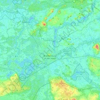
Nom : Carte topographique Brandenburg an der Havel, altitude, relief.
Lieu : Brandenburg an der Havel, Brandenburg, Germany (52.31163 12.36109 52.54183 12.72578)
Altitude moyenne : 36 m
Altitude minimum : 25 m
Altitude maximum : 101 m
Faire un don
Équipez-vous pour votre prochaine aventure :
En tant que Partenaire Amazon, ce site perçoit une commission sur les achats éligibles sans surcoût pour vous.
Autres cartes topographiques
Cliquez sur une carte pour visualiser sa topographie, son altitude et son relief.
North European Plain
Germany > Brandenburg > Ostprignitz-Ruppin > Lindow (Mark)
Elevations vary between 0 and 200 m (0 to about 650 ft). While mostly used as farmland, the region also contains bogs, heath and lakes. The Wadden Sea, a large tidal area, is located on the North Sea coast.
Altitude moyenne : 54 m
Potsdam
Germany > Brandenburg > Potsdam
The traditional towns in the governorate were small, however, in the course of the industrial labour migration some reached the rank of urban districts. The principal towns were Brandenburg upon Havel, Köpenick, Potsdam, Prenzlau, Spandau and Ruppin. Until 1875 Berlin also was a town within the governorate.…
Altitude moyenne : 43 m
Faire un don
Équipez-vous pour votre prochaine aventure :
En tant que Partenaire Amazon, ce site perçoit une commission sur les achats éligibles sans surcoût pour vous.
North European Plain
Germany > Brandenburg > Ostprignitz-Ruppin > Lindow (Mark) > Banzendorf
Elevations vary between 0 and 200 m (0 to about 650 ft). While mostly used as farmland, the region also contains bogs, heath and lakes. The Wadden Sea, a large tidal area, is located on the North Sea coast.
Altitude moyenne : 54 m
Faire un don
Équipez-vous pour votre prochaine aventure :
En tant que Partenaire Amazon, ce site perçoit une commission sur les achats éligibles sans surcoût pour vous.
Groß Gastrose - Wjeliki Gósćeraz
Germany > Brandenburg > Spree-Neiße - Sprjewja-Nysa
Altitude moyenne : 59 m
Faire un don
Équipez-vous pour votre prochaine aventure :
En tant que Partenaire Amazon, ce site perçoit une commission sur les achats éligibles sans surcoût pour vous.
Birkenstein
Germany > Brandenburg > Märkisch-Oderland > Hoppegarten > Dahlwitz-Hoppegarten
Altitude moyenne : 55 m
Preilack - Pśiłuk
Germany > Brandenburg > Spree-Neiße - Sprjewja-Nysa > Turnow-Preilack
Altitude moyenne : 66 m
Faire un don
Équipez-vous pour votre prochaine aventure :
En tant que Partenaire Amazon, ce site perçoit une commission sur les achats éligibles sans surcoût pour vous.
Siedlung Waldesruh
Germany > Brandenburg > Dahme-Spreewald > Königs Wusterhausen
Altitude moyenne : 41 m
Kochsdorf - Kochanojce
Germany > Brandenburg > Spree-Neiße - Sprjewja-Nysa > Spremberg
Altitude moyenne : 123 m
Faire un don
Équipez-vous pour votre prochaine aventure :
En tant que Partenaire Amazon, ce site perçoit une commission sur les achats éligibles sans surcoût pour vous.
Faire un don
Équipez-vous pour votre prochaine aventure :
En tant que Partenaire Amazon, ce site perçoit une commission sur les achats éligibles sans surcoût pour vous.