
Faire un don
Équipez-vous pour votre prochaine aventure :
En tant que Partenaire Amazon, ce site perçoit une commission sur les achats éligibles sans surcoût pour vous.
Carte topographique Mansfield Woodhouse
Cliquez sur la carte pour afficher l’altitude.
Faire un don
Équipez-vous pour votre prochaine aventure :
En tant que Partenaire Amazon, ce site perçoit une commission sur les achats éligibles sans surcoût pour vous.
À propos de cette carte
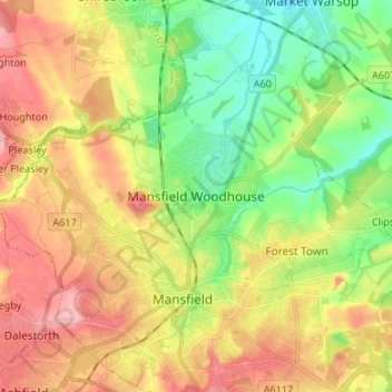
Nom : Carte topographique Mansfield Woodhouse, altitude, relief.
Altitude moyenne : 114 m
Altitude minimum : 58 m
Altitude maximum : 177 m
Faire un don
Équipez-vous pour votre prochaine aventure :
En tant que Partenaire Amazon, ce site perçoit une commission sur les achats éligibles sans surcoût pour vous.
Autres cartes topographiques
Cliquez sur une carte pour visualiser sa topographie, son altitude et son relief.
Nottingham Canal
United Kingdom > England > Nottinghamshire > Nottingham > Beeston
Altitude moyenne : 33 m
East Stoke CP
United Kingdom > England > Nottinghamshire > Newark and Sherwood
Altitude moyenne : 24 m
Faire un don
Équipez-vous pour votre prochaine aventure :
En tant que Partenaire Amazon, ce site perçoit une commission sur les achats éligibles sans surcoût pour vous.
Epperstone CP
United Kingdom > England > Nottinghamshire > Newark and Sherwood
The report notes Epperstone's "very distinctive character... a combination of topography, buildings, trees and walls.... The constantly changing views make it an attractive space to move through." It also notes, "The approach to the village from the west is along a tunnel formed by overhanging trees, including…
Altitude moyenne : 69 m