
Faire un don
Équipez-vous pour votre prochaine aventure :
En tant que Partenaire Amazon, ce site perçoit une commission sur les achats éligibles sans surcoût pour vous.
Carte topographique Pendlebury
Cliquez sur la carte pour afficher l’altitude.
Faire un don
Équipez-vous pour votre prochaine aventure :
En tant que Partenaire Amazon, ce site perçoit une commission sur les achats éligibles sans surcoût pour vous.
Pendlebury
Pendlebury is situated on a ridge overlooking the lower Irwell Valley, almost midway between Manchester and Bolton and is neighboured by Irlams o' th' Height, Pendleton and Clifton. Much of the boundary between Pendlebury and Clifton is defined by Slack Brook which was culverted many years ago after the area was used for landfill. Slack Brook eventually empties into the Irwell a short distance upstream from Agecroft Road Bridge (A6044). The surface of the land slopes generally upwards from southwest (Swinton) to northeast (Irwell Valley), from about 120 feet (40 m) to nearly 300 feet (90 m) above the ordnance datum. However, the topography of the land around Lumn's Lane has changed due to the dumping of mining waste from the former collieries and the area has been used as a landfill site by the Greater Manchester Waste Disposal Authority since 1982, taking ten percent of Greater Manchester's waste each year.
Faire un don
Équipez-vous pour votre prochaine aventure :
En tant que Partenaire Amazon, ce site perçoit une commission sur les achats éligibles sans surcoût pour vous.
À propos de cette carte
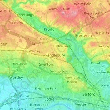
Nom : Carte topographique Pendlebury, altitude, relief.
Altitude moyenne : 64 m
Altitude minimum : 18 m
Altitude maximum : 138 m
Faire un don
Équipez-vous pour votre prochaine aventure :
En tant que Partenaire Amazon, ce site perçoit une commission sur les achats éligibles sans surcoût pour vous.
Autres cartes topographiques
Cliquez sur une carte pour visualiser sa topographie, son altitude et son relief.
Faire un don
Équipez-vous pour votre prochaine aventure :
En tant que Partenaire Amazon, ce site perçoit une commission sur les achats éligibles sans surcoût pour vous.