Géolocaliser

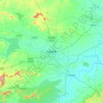
Carte topographique Nashik

Cliquez sur la carte pour afficher l’altitude.

Nashik

The city's tropical location and high altitude combine to give it a relatively mild version of a tropical wet and dry climate (Köppen Aw). Temperatures rise slightly in October, but this is followed by the cool season from November to February. The cool season sees warm temperatures of around 28 °C or 82.4 °F during the day, but cool nights, with lows averaging 10 °C or 50 °F, and extremely dry air.

Wikipedia (CC-BY-SA 3.0)

À propos de cette carte

Nom : Carte topographique Nashik, altitude, relief.

Lieu : Nashik, Nashik Taluka, Nashik District, Maharashtra, 422001, India (19.85125 73.63024 20.17125 73.95024)

Altitude moyenne : 631 m

Altitude minimum : 535 m

Altitude maximum : 1 079 m

Équipez-vous pour votre prochaine aventure :

🎒Poche à eau pour sac à dos - Hydratation facile sans s'arrêter de marcher
🧰Outils multifonctions - Polyvalence et compacité
👣Semelles de remplacement confort - Améliorez le soutien de vos bottes pour les longues marches
📦Rangement matériel outdoor - Organisation de l'équipement
🧺Ensemble de sacs étanches - Compartimentez et protégez vos vêtements dans votre sac

En tant que Partenaire Amazon, ce site perçoit une commission sur les achats éligibles sans surcoût pour vous.