
Carte topographique Kunming
Carte interactive
Cliquez sur la carte pour afficher l’altitude.
À propos de cette carte
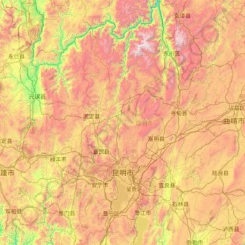
Nom : Carte topographique Kunming, altitude, relief.
Lieu : Kunming, Yunnan, China (24.38885 102.16974 26.54849 103.66835)
Altitude moyenne : 2 005 m
Altitude minimum : 714 m
Altitude maximum : 4 151 m
Situated in a fertile lake basin on the northern shore of the Lake Dian and surrounded by mountains to the north, west, and east, Kunming has always played a pivotal role in the communications of southwestern China. Lake Dian, known as "the Pearl of the Plateau", is the largest lake in Yunnan and the sixth largest fresh water lake in China. It has an area of approximately 340 square kilometres (130 square miles). Kunming's highest point is Mazong Ridge of the Jiaozi Mountain in Luquan with an elevation of 4,247 metres (13,934 feet), and its lowest point is the joint of the Xiao River and the Jinsha River in Dongchuan District, with an elevation of 695 metres (2,280 feet). Its downtown area is 1,891 metres (6,204 feet) above sea level.