
Carte topographique Johannesburg Ward 87
Carte interactive
Cliquez sur la carte pour afficher l’altitude.
À propos de cette carte
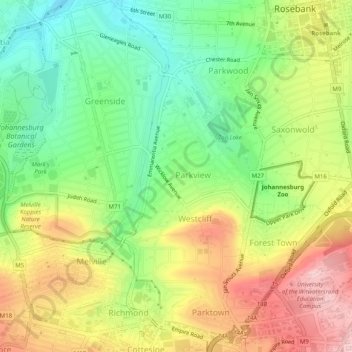
Nom : Carte topographique Johannesburg Ward 87, altitude, relief.
Altitude moyenne : 1 661 m
Altitude minimum : 1 562 m
Altitude maximum : 1 783 m
Autres cartes topographiques
Cliquez sur une carte pour visualiser sa topographie, son altitude et son relief.
Zoo Lake
RSA > Gauteng > Johannesburg
Zoo Lake, Johannesburg Ward 117, Johannesburg, City of Johannesburg Metropolitan Municipality, Gauteng, 2001, RSA
Altitude moyenne : 1 647 m
Braamfontein Spruit
RSA > Gauteng > Johannesburg
Braamfontein Spruit, Johannesburg, City of Johannesburg Metropolitan Municipality, Gauteng, 2001, RSA
Altitude moyenne : 1 672 m
Johannesburg Ward 60
RSA > Gauteng > Johannesburg
Johannesburg Ward 60, Johannesburg, City of Johannesburg Metropolitan Municipality, Gauteng, 2001, RSA
Altitude moyenne : 1 736 m
Kliprivier
RSA > Gauteng > Johannesburg
Kliprivier, Johannesburg, City of Johannesburg Metropolitan Municipality, Gauteng, 2001, RSA
Altitude moyenne : 1 531 m
Mary Fitzgerald Square
RSA > Gauteng > Johannesburg
Mary Fitzgerald Square, Johannesburg Ward 60, Johannesburg, City of Johannesburg Metropolitan Municipality, Gauteng, 2001, RSA
Altitude moyenne : 1 738 m