
Carte topographique Deep River
Cliquez sur la carte pour afficher l’altitude.
Deep River
John Bland, an architecture professor at McGill University, developed the town's first master plan in 1944. Bland located the town between the existing Highway 17 and the Ottawa River. He designed a system of streets which generally followed the contours of the area's topography. Residential neighborhoods stretched out from a commercial and service-sector core. Straight and broad avenues ran along contour lines, while narrower and winding streets lay at right angles, discouraging non-local traffic from entering neighborhoods. Parks and schools were located strategically throughout the town. The streets were named after local flora, Canadian politicians and famous scientists such as Ernest Rutherford and Charles Darwin.
À propos de cette carte
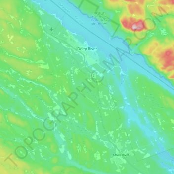
Nom : Carte topographique Deep River, altitude, relief.
Altitude moyenne : 169 m
Altitude minimum : 103 m
Altitude maximum : 411 m
Autres cartes topographiques
Cliquez sur une carte pour visualiser sa topographie, son altitude et son relief.
Mount St. Patrick Mountains
Canada > Ontario > Renfrew County > Greater Madawaska
Altitude moyenne : 390 m
Foymount
Canada > Ontario > Renfrew County > Bonnechere Valley
The location is also popular for amateur astronomers given the high altitude and low levels of artificial light.
Altitude moyenne : 432 m
Palmer Rapids
Canada > Ontario > Renfrew County > Brudenell, Lyndoch and Raglan
Altitude moyenne : 319 m
Bonnechere
Canada > Ontario > Renfrew County > Killaloe, Hagarty and Richards
Altitude moyenne : 174 m
Madawaska River
Canada > Ontario > Renfrew County > Greater Madawaska > Calabogie
Altitude moyenne : 160 m
Lorwall Lake
Canada > Ontario > Renfrew County > Brudenell, Lyndoch and Raglan
Altitude moyenne : 401 m
Madawaska Highlands
Canada > Ontario > Renfrew County > Killaloe, Hagarty and Richards
Altitude moyenne : 272 m