
Carte topographique Alwar
Carte interactive
Cliquez sur la carte pour afficher l’altitude.
À propos de cette carte
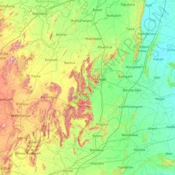
Nom : Carte topographique Alwar, altitude, relief.
Lieu : Alwar, Rajasthan, India (26.86000 75.86000 28.14000 77.14000)
Altitude moyenne : 329 m
Altitude minimum : 184 m
Altitude maximum : 820 m
Autres cartes topographiques
Cliquez sur une carte pour visualiser sa topographie, son altitude et son relief.
Merda Khalsa
India > Rajasthan > Amet Tehsil
Merda Khalsa, Amet Tehsil, Rajsamand District, Rajasthan, India
Altitude moyenne : 619 m
Madri
India > Rajasthan > Jhadol Tehsil
Madri, Jhadol Tehsil, Udaipur District, Rajasthan, India
Altitude moyenne : 710 m
Rawatpura Toos
India > Rajasthan > Vallabhnagar Tehsil
Rawatpura Toos, Vallabhnagar Tehsil, Udaipur District, Rajasthan, 313022, India
Altitude moyenne : 515 m
Keoladeo Ghana National Park
Keoladeo Ghana National Park, Agra Jaipur Bikaner Road, Bharatpur, Bharatpur Tehsil, Bharatpur, Rajasthan, 321001, India
Altitude moyenne : 177 m
Sawāi Mādhopur
Sawāi Mādhopur, Sawai Madhopur, Rajasthan, 322200, India
Altitude moyenne : 275 m