
Carte topographique Spokane
Carte interactive
Cliquez sur la carte pour afficher l’altitude.
À propos de cette carte
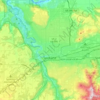
Nom : Carte topographique Spokane, altitude, relief.
Lieu : Spokane, Spokane County, Washington, United States (47.58678 -117.60400 47.75880 -117.30386)
Altitude moyenne : 655 m
Altitude minimum : 470 m
Altitude maximum : 1 116 m
Spokane is located on the Spokane River in eastern Washington at an elevation of 1,843 feet (562 m) above sea level, about 18 miles (29 km) from Idaho, 92 miles (148 km) south of the Canadian border, 229 miles (369 km) due east of Seattle, and 279 miles (449 km) southwest of Calgary. The lowest elevation in the city of Spokane is the northernmost point of the Spokane River within city limits (in Riverside State Park) at 1,608 feet (490 m); the highest elevation is on the northeast side, near the community of Hillyard (though closer to Beacon Hill and the North Hill Reservoir) at 2,591 feet (790 m). Spokane is part of the Inland Northwest region, consisting of eastern Washington, north Idaho, northwestern Montana, and northeastern Oregon. The city has a total area of 60.02 square miles (155.45 km2), of which 59.25 square miles (153.46 km2) is land and 0.77 square miles (1.99 km2) is water.
Autres cartes topographiques
Cliquez sur une carte pour visualiser sa topographie, son altitude et son relief.
Newman Lake
United States > Washington > Spokane County
Newman Lake, Spokane County, Washington, 99025, United States
Altitude moyenne : 661 m
Hog Lake
United States > Washington > Spokane County
Hog Lake, Spokane County, Washington, United States
Altitude moyenne : 664 m
Silver Lake
United States > Washington > Spokane County
Silver Lake, Spokane County, Washington, 99022, United States
Altitude moyenne : 741 m
Mead
United States > Washington > Spokane County
Mead, Spokane County, Washington, 99021, United States
Altitude moyenne : 585 m
Country Homes
United States > Washington > Spokane County
Country Homes, Spokane County, Washington, 99251, United States
Altitude moyenne : 599 m
Airway Heights
United States > Washington > Spokane County
Airway Heights, Spokane County, Washington, 99001, United States
Altitude moyenne : 724 m
Millwood
United States > Washington > Spokane County
Millwood, Spokane County, Washington, United States
Altitude moyenne : 600 m
Cheney
United States > Washington > Spokane County
Cheney, Spokane County, Washington, United States
Altitude moyenne : 728 m
Deer Park
United States > Washington > Spokane County
Deer Park, Spokane County, Washington, 99006, United States
Altitude moyenne : 658 m
Mount Spokane
United States > Washington > Spokane County
Mount Spokane, Spokane County, Washington, United States
Altitude moyenne : 1 475 m
Liberty Lake
United States > Washington > Spokane County
Liberty Lake, Spokane County, Washington, 99019, United States
Altitude moyenne : 644 m
Spokane Valley
United States > Washington > Spokane County
Spokane Valley, Spokane County, Washington, United States
Altitude moyenne : 673 m
Nine Mile Falls
United States > Washington > Spokane County
Nine Mile Falls, Spokane County, Washington, 99026, United States
Altitude moyenne : 536 m
Riverside State Park
United States > Washington > Spokane County > Spokane
Riverside State Park, Spokane, Spokane County, Washington, United States
Altitude moyenne : 645 m
Medical Lake
United States > Washington > Spokane County
Medical Lake, Spokane County, Washington, 99022, United States
Altitude moyenne : 738 m
Medical Lake
United States > Washington > Spokane County > Medical Lake > Medical Lake
Medical Lake, Spokane County, Washington, 99022, United States
Altitude moyenne : 747 m
Chattaroy
United States > Washington > Spokane County > Chattaroy
Chattaroy, Spokane County, Washington, 99005, United States
Altitude moyenne : 559 m