
Carte topographique Espoo
Carte interactive
Cliquez sur la carte pour afficher l’altitude.
À propos de cette carte
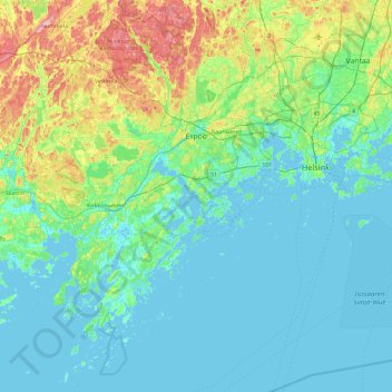
Nom : Carte topographique Espoo, altitude, relief.
Altitude moyenne : 22 m
Altitude minimum : -3 m
Altitude maximum : 117 m
The minerals and structures of the rocky and hilly topography of Espoo were formed about 1880 to 1650 million years ago. Particularly the Weichselian glaciation has had an effect on the current environment - the continental ice sheet withdrew from what is now Espoo about 13 thousand years ago. The first areas to surface from underneath the sea were the high hills in northern Espoo, such as Mustankorvenkallio. The numerous smooth cliffs on the seashore and in the archipelago were caused by wear by the continental ice sheet; there are grooves on their surfaces, indicating the direction of the flow of the ice sheet. Icebergs split off from the ice sheet have transported glacial erratics, including those in Kunnarla, Soukka and Suomenoja.
Autres cartes topographiques
Cliquez sur une carte pour visualiser sa topographie, son altitude et son relief.
Tapionranta
Tapionranta, 39, Päiväkumpu, Koivukylän suuralue, Vantaa, Helsinki sub-region, Uusimaa, Southern Finland, Mainland Finland, 01420, Finland
Altitude moyenne : 33 m
Viikin tiedepuisto
Viikin tiedepuisto, Viikki, Northeastern major district, Helsinki, Helsinki sub-region, Uusimaa, Southern Finland, Mainland Finland, 00790, Finland
Altitude moyenne : 13 m
Kannelmäki
Kannelmäki, Kaarela, Western major district, Helsinki, Helsinki sub-region, Uusimaa, Southern Finland, Mainland Finland, 00420, Finland
Altitude moyenne : 26 m
Helsinki sub-region
Helsinki sub-region, Uusimaa, Southern Finland, Mainland Finland, Finland
Altitude moyenne : 51 m
Länsisatama
Länsisatama, Southern major district, Helsinki, Helsinki sub-region, Uusimaa, Southern Finland, Mainland Finland, Finland
Altitude moyenne : 7 m
Fågelsjö
Finland > Uusimaa > Kirkkonummi
Fågelsjö, Eteläinen Kirkkonummi, Kirkkonummi, Helsinki sub-region, Uusimaa, Southern Finland, Mainland Finland, Finland
Altitude moyenne : 4 m