
Faire un don
Équipez-vous pour votre prochaine aventure :
En tant que Partenaire Amazon, ce site perçoit une commission sur les achats éligibles sans surcoût pour vous.
Carte topographique The West Lion
Cliquez sur la carte pour afficher l’altitude.
Faire un don
Équipez-vous pour votre prochaine aventure :
En tant que Partenaire Amazon, ce site perçoit une commission sur les achats éligibles sans surcoût pour vous.
The West Lion
Hikers can climb up to the ridge between the East and West Lion peaks using either the Binkert Trail leading up from Lions Bay, or the Howe Sound Crest Trail. The Binkert Trail, named after Paul Binkert of the British Columbia Mountaineering Club, is one of the most popular in the Lower Mainland. Hiking to the ridge from Lions Bay takes approximately four hours and gains 1,280 m (4,199 ft) in elevation. Most hikers stop there as both the East and West Lion peaks require rock climbing equipment and expertise. The East Lion is out-of-bounds for climbing as it is located in the Greater Vancouver watershed.
Faire un don
Équipez-vous pour votre prochaine aventure :
En tant que Partenaire Amazon, ce site perçoit une commission sur les achats éligibles sans surcoût pour vous.
À propos de cette carte
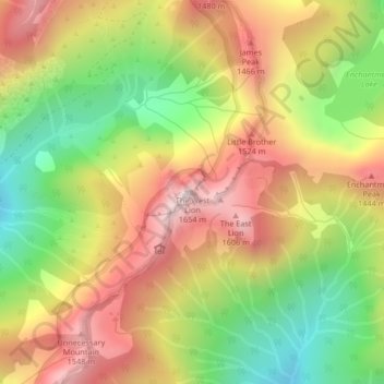
Nom : Carte topographique The West Lion, altitude, relief.
Altitude moyenne : 1 159 m
Altitude minimum : 724 m
Altitude maximum : 1 585 m
Faire un don
Équipez-vous pour votre prochaine aventure :
En tant que Partenaire Amazon, ce site perçoit une commission sur les achats éligibles sans surcoût pour vous.
Autres cartes topographiques
Cliquez sur une carte pour visualiser sa topographie, son altitude et son relief.
Coquitlam Watershed
Canada > British Columbia > Metro Vancouver Regional District > Electoral Area A
Altitude moyenne : 673 m
Metro Vancouver Regional Parks
Canada > British Columbia > Metro Vancouver Regional District > Electoral Area A
Altitude moyenne : 191 m