
Carte topographique Knottenried
Cliquez sur la carte pour afficher l’altitude.
Knottenried
Der Höhenfestpunkt für Knottenried ist in die Mauer der Pfarrkirche eingeschlagen und liegt auf 1003 m über NHN. Der mit 1056 m ü. NHN höchste Punkt der Pfarrei ist westlich von Knottenried auf der im amtlichen Grundbeschrieb als „Prageck“ benannten Flurbezeichnung. Der tiefste Punkt ist das Mühlbach-Tobel südlichöstlich von Reute am Übergang zur Gemarkung Akams mit 900 m über NHN.
À propos de cette carte
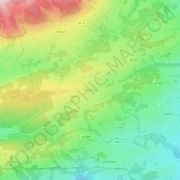
Nom : Carte topographique Knottenried, altitude, relief.
Altitude moyenne : 948 m
Altitude minimum : 766 m
Altitude maximum : 1 235 m
Autres cartes topographiques
Cliquez sur une carte pour visualiser sa topographie, son altitude et son relief.
Großer Alpsee
Deutschland > Bayern > Landkreis Oberallgäu > Immenstadt im Allgäu > Bühl am Alpsee
Weniger als 200 Meter oberhalb des westlichen Ufers liegt der 4,6 ha große Teufelssee, ein Restgewässer aus der Zeit, als der See noch weiter nach Westen reichte. Er liegt im Naturpark Nagelfluhkette und grenzt im Norden an den Salmaser Höhenzug, der die nördliche Grenze der Allgäuer Alpen darstellt. Im…
Altitude moyenne : 821 m
Kleiner Alpsee
Deutschland > Bayern > Landkreis Oberallgäu > Immenstadt im Allgäu > Bühl am Alpsee
Altitude moyenne : 855 m