
Carte topographique Ganges
Carte interactive
Cliquez sur la carte pour afficher l’altitude.
À propos de cette carte
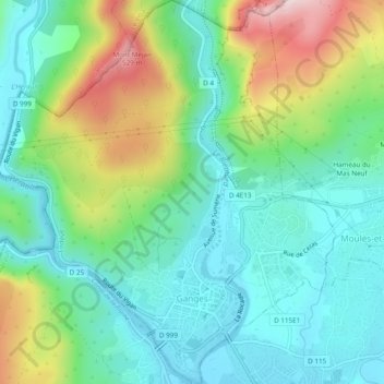
Nom : Carte topographique Ganges, altitude, relief.
Altitude moyenne : 261 m
Altitude minimum : 139 m
Altitude maximum : 547 m
The upper phase of the river Ganges begins at the confluence of the Bhagirathi and Alaknanda rivers in the town of Devprayag in the Garhwal division of the Indian state of Uttarakhand. The Bhagirathi is considered to be the source in Hindu culture and mythology, although the Alaknanda is longer, and therefore, hydrologically the source stream. The headwaters of the Alakananda are formed by snow melt from peaks such as Nanda Devi, Trisul, and Kamet. The Bhagirathi rises at the foot of Gangotri Glacier, at Gomukh, at an elevation of 4,356 m (14,291 ft) and being mythologically referred to as residing in the matted locks of Shiva; symbolically Tapovan, which is a meadow of ethereal beauty at the feet of Mount Shivling, just 5 km (3.1 mi) away.