
Carte topographique Legazpi
Carte interactive
Cliquez sur la carte pour afficher l’altitude.
À propos de cette carte
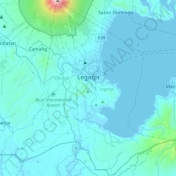
Nom : Carte topographique Legazpi, altitude, relief.
Lieu : Legazpi, Albay, Bicol Region, 4500, Philippines (12.98740 123.68618 13.25551 123.86397)
Altitude moyenne : 124 m
Altitude minimum : -2 m
Altitude maximum : 2 431 m
Legazpi's topography is generally plain on the northeastern areas, with slopes ranging from five to fifteen degrees. The southern areas have mostly rolling to hilly terrain. In the city's coastal areas, the terrain varies from plain (north) to hilly (south). Legazpi is criss-crossed by several rivers including the Tibu, Macabalo and Yawa rivers with a number of swampy areas, particularly in the urban district. To mitigate flooding in these low-lying areas, the local government has built an urban drainage and flood control system consisting of dikes, canals, sea walls and three pumping stations located in Barangays San Roque, Bay-Bay and Victory Village.
Autres cartes topographiques
Cliquez sur une carte pour visualiser sa topographie, son altitude et son relief.
Bacolod
Philippines > Albay > Tabaco
Bacolod, Tabaco, Albay, Bicol Region, 4511, Philippines
Altitude moyenne : 7 m
Nabasan
Philippines > Albay > Daraga
Nabasan, Daraga, Albay, Bicol Region, Philippines
Altitude moyenne : 59 m
Mayon Volcano
Philippines > Albay > Magapo
Mayon Volcano, Mt. Mayon Park Road, Magapo, Albay, Bicol Region, Philippines
Altitude moyenne : 519 m