
Carte topographique Newbury
Carte interactive
Cliquez sur la carte pour afficher l’altitude.
À propos de cette carte
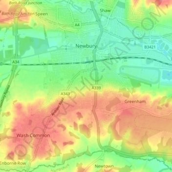
Nom : Carte topographique Newbury, altitude, relief.
Lieu : Newbury, West Berkshire, England, United Kingdom (51.36711 -1.35315 51.41456 -1.28819)
Altitude moyenne : 97 m
Altitude minimum : 64 m
Altitude maximum : 135 m
Elevations vary from a minimum of 72 m above mean sea level to 122 m at Wash Common. Elevations reach 150–200 m in the directly adjoining hills. The River Kennet and the Kennet and Avon Canal flow east through the centre of the town to reach the Thames at Reading, while the River Lambourn (beside which is the country's largest horse-training paddocks in the Valley of the Lambourn Downs) partly forms its northern boundary, ending in the town. A tributary that is smaller still, the River Enborne, forms the southern boundary (and also the county boundary with Hampshire).
Autres cartes topographiques
Cliquez sur une carte pour visualiser sa topographie, son altitude et son relief.
Welford
United Kingdom > England > West Berkshire
Welford, West Berkshire, England, United Kingdom
Altitude moyenne : 124 m
Great Shefford
United Kingdom > England > West Berkshire
Great Shefford, West Berkshire, England, United Kingdom
Altitude moyenne : 148 m
Bradfield
United Kingdom > England > West Berkshire
Bradfield, West Berkshire, England, United Kingdom
Altitude moyenne : 77 m
Shaw
United Kingdom > England > West Berkshire
Shaw, West Berkshire, England, RG14 2DF, United Kingdom
Altitude moyenne : 93 m
Hungerford
United Kingdom > England > West Berkshire
Hungerford, West Berkshire, England, United Kingdom
Altitude moyenne : 131 m
Mortimer
United Kingdom > England > West Berkshire > Mortimer
Mortimer, West Berkshire, South East England, England, RG7 3RD, United Kingdom
Altitude moyenne : 80 m
Reading
United Kingdom > England > West Berkshire > Reading
Reading, West Berkshire, South East England, England, RG1 1DA, United Kingdom
Altitude moyenne : 56 m
Burghfield
United Kingdom > England > West Berkshire > Burghfield
Burghfield, West Berkshire, England, United Kingdom
Altitude moyenne : 53 m
Brightwalton
United Kingdom > England > West Berkshire
Brightwalton, West Berkshire, England, United Kingdom
Altitude moyenne : 178 m
Pangbourne
United Kingdom > England > West Berkshire > Pangbourne
Pangbourne, West Berkshire, South East England, England, United Kingdom
Altitude moyenne : 64 m
Beenham
United Kingdom > England > West Berkshire > Beenham
Beenham, West Berkshire, South East England, England, United Kingdom
Altitude moyenne : 77 m
Berkshire
United Kingdom > England > West Berkshire
Berkshire, West Berkshire, England, United Kingdom
Altitude moyenne : 100 m