
Carte topographique Isabela
Carte interactive
Cliquez sur la carte pour afficher l’altitude.
Isabela
The elevation of Isabela to 4th-class city status gave the local government a much-needed boost, efficiently delivered under the Biel administration, revitalized Isabela City, making it an engine of growth for Basilan province even as the hinterlands was wracked by incessant firefights and gun-battles between the military and bandit groups such as the Abu Sayyaf and Moro Islamic Liberation Front (MILF).
À propos de cette carte
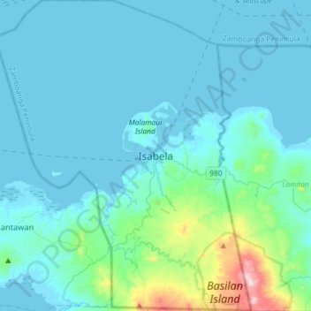
Nom : Carte topographique Isabela, altitude, relief.
Lieu : Isabela, Basilan, Zamboanga Peninsula, 7300, Philippines (6.56196 121.82151 6.84919 122.05996)
Altitude moyenne : 93 m
Altitude minimum : -2 m
Altitude maximum : 915 m
Autres cartes topographiques
Cliquez sur une carte pour visualiser sa topographie, son altitude et son relief.