
Carte topographique Davidson Glacier
Carte interactive
Cliquez sur la carte pour afficher l’altitude.
À propos de cette carte
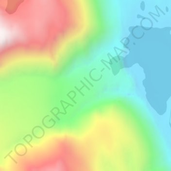
Nom : Carte topographique Davidson Glacier, altitude, relief.
Lieu : Davidson Glacier, Haines, Alaska, USA (59.08658 -135.44828 59.08668 -135.44818)
Altitude moyenne : 416 m
Altitude minimum : 17 m
Altitude maximum : 1 056 m
Autres cartes topographiques
Cliquez sur une carte pour visualiser sa topographie, son altitude et son relief.
Mendenhaven
USA > Alaska > Mendenhaven
Mendenhaven, Juneau, Alaska, 99801, USA
Altitude moyenne : 126 m
Gannett Glacier
Gannett Glacier, Unorganized Borough, Alaska, USA
Altitude moyenne : 1 571 m
Admiralty Island
Admiralty Island, Hoonah-Angoon, Alaska, 99820, USA
Altitude moyenne : 295 m
Caldwell Glacier
Caldwell Glacier, Matanuska-Susitna, Alaska, USA
Altitude moyenne : 1 569 m
Kuskokwim River
Kuskokwim River, Unorganized Borough, Alaska, USA
Altitude moyenne : 111 m
Princeton Glacier
Princeton Glacier, Unorganized Borough, Alaska, USA
Altitude moyenne : 621 m
Cul-de-Sac Glacier
Cul-de-Sac Glacier, Matanuska-Susitna, Alaska, USA
Altitude moyenne : 1 541 m
Byron Glacier
Byron Glacier, Byron Glacier Trail, Anchorage, Alaska, USA
Altitude moyenne : 749 m
Mount Marcus Baker
Mount Marcus Baker, Matanuska-Susitna, Alaska, USA
Altitude moyenne : 3 435 m
Chugach Mountains
Chugach Mountains, Matanuska-Susitna, Alaska, USA
Altitude moyenne : 2 530 m
Shadows Glacier
Shadows Glacier, Matanuska-Susitna, Alaska, USA
Altitude moyenne : 1 464 m
Madre de Dios Island
Madre de Dios Island, Prince of Wales-Hyder, Alaska, USA
Altitude moyenne : 12 m