
Carte topographique Twin Peak
Carte interactive
Cliquez sur la carte pour afficher l’altitude.
À propos de cette carte
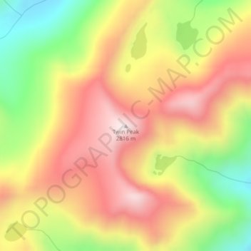
Nom : Carte topographique Twin Peak, altitude, relief.
Lieu : Twin Peak, Idaho County, Idaho, USA (45.27181 -114.75070 45.27191 -114.75060)
Altitude moyenne : 2 497 m
Altitude minimum : 2 122 m
Altitude maximum : 2 808 m
Autres cartes topographiques
Cliquez sur une carte pour visualiser sa topographie, son altitude et son relief.
Lake Pend Oreille
Lake Pend Oreille, National Forest Development Road 2711, Granite, Bonner County, Idaho, USA
Altitude moyenne : 941 m
Selway-Bitterroot Wilderness Area
Selway-Bitterroot Wilderness Area, Idaho County, Idaho, USA
Altitude moyenne : 1 647 m
Payette National Forest
Payette National Forest, Lick Creek Road, Valley County, Idaho, USA
Altitude moyenne : 1 757 m
Nez Perce National Forest
Nez Perce National Forest, Crooked River Road, Orogrande, Idaho County, Idaho, USA
Altitude moyenne : 1 549 m
Clearwater National Forest
Clearwater National Forest, Lolo Motor Way, Idaho County, Idaho, USA
Altitude moyenne : 1 425 m
Kootenay River
Kootenay River, Boundary County, Idaho, 83845, USA
Altitude moyenne : 1 271 m
American Falls Reservoir
American Falls Reservoir, Beach Road, Fingal, Bingham County, Idaho, USA
Altitude moyenne : 1 358 m
Island Park
Island Park, Salmon, Lemhi County, Idaho, USA
Altitude moyenne : 1 222 m
Little Rocky Island
USA > Idaho > Walters Ferry
Little Rocky Island, Walters Ferry, Owyhee County, Idaho, USA
Altitude moyenne : 713 m
Cathedral Pines
USA > Idaho > Cathedral Pines
Cathedral Pines, Blaine County, Idaho, USA
Altitude moyenne : 2 179 m
Grandfather Mountain
Grandfather Mountain, Shoshone County, Idaho, USA
Altitude moyenne : 1 657 m
Hells Canyon Wilderness
Hells Canyon Wilderness, Idaho County, Idaho, USA
Altitude moyenne : 1 419 m
White Canyon Creek
White Canyon Creek, Franklin County, Idaho, USA
Altitude moyenne : 2 482 m
Gospel-Hump Wilderness Area
Gospel-Hump Wilderness Area, National Forest Development Road 313, Concord, Idaho County, Idaho, USA
Altitude moyenne : 1 755 m
Craters of the Moon National Monument & Preserve
Craters of the Moon National Monument & Preserve, Blaine County, Idaho, USA
Altitude moyenne : 1 546 m