
Carte topographique Caltanissetta
Carte interactive
Cliquez sur la carte pour afficher l’altitude.
À propos de cette carte
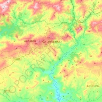
Nom : Carte topographique Caltanissetta, altitude, relief.
Lieu : Caltanissetta, Sicily, 93100, Italy (37.32933 13.86167 37.59813 14.15923)
Altitude moyenne : 428 m
Altitude minimum : 158 m
Altitude maximum : 849 m
In 2017, the city had a population of 62,797.[4] It is the 14th largest comune in Italy measured by area, the sixth highest comune in Italy by elevation (568 m), the second highest elevation in Sicily after the city of Enna (912 m).
Autres cartes topographiques
Cliquez sur une carte pour visualiser sa topographie, son altitude et son relief.
Bompensiere
Italy > Sicily > Caltanissetta
Bompensiere, Caltanissetta, Sicily, 93010, Italy
Altitude moyenne : 319 m
Mussomeli
Italy > Sicily > Caltanissetta
Mussomeli, Caltanissetta, Sicily, 93014, Italy
Altitude moyenne : 420 m