
Carte topographique Cheung Tsui Chau
Carte interactive
Cliquez sur la carte pour afficher l’altitude.
À propos de cette carte
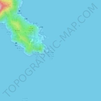
Nom : Carte topographique Cheung Tsui Chau, altitude, relief.
Altitude moyenne : 8 m
Altitude minimum : 0 m
Altitude maximum : 196 m
Autres cartes topographiques
Cliquez sur une carte pour visualiser sa topographie, son altitude et son relief.
Wong Mau Chau
Wong Mau Chau, Tung Wan, Sai Kung District, Hong Kong, PRC
Altitude moyenne : 3 m
Breaker Reef
Breaker Reef, Shore of Thousand Creek (Chin Kai Hoi On), Tai Long, Tung Wan, Sai Kung District, Hong Kong, PRC
Altitude moyenne : 0 m