
Carte topographique Drongen
Carte interactive
Cliquez sur la carte pour afficher l’altitude.
À propos de cette carte
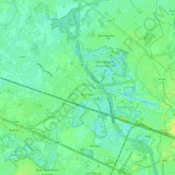
Nom : Carte topographique Drongen, altitude, relief.
Lieu : Drongen, Ghent, Gent, East Flanders, 9031, Belgium (51.02187 3.57976 51.08425 3.68508)
Altitude moyenne : 7 m
Altitude minimum : -8 m
Altitude maximum : 19 m
Autres cartes topographiques
Cliquez sur une carte pour visualiser sa topographie, son altitude et son relief.
Zwijnaarde
Belgium > East Flanders > Gent > Ghent
Zwijnaarde, Ghent, Gent, East Flanders, 9052, Belgium
Altitude moyenne : 9 m
Afsnee
Belgium > East Flanders > Gent > Ghent
Afsnee, Ghent, Gent, East Flanders, Belgium
Altitude moyenne : 7 m
Ghent
Belgium > East Flanders > Gent > Ghent
Ghent, Gent, East Flanders, Flanders, 24-32, Belgium
Altitude moyenne : 12 m