
Carte topographique Brunswick
Carte interactive
Cliquez sur la carte pour afficher l’altitude.
À propos de cette carte
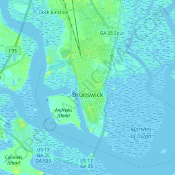
Nom : Carte topographique Brunswick, altitude, relief.
Lieu : Brunswick, Glynn County, Georgia, United States (31.10341 -81.53020 31.20499 -81.40078)
Altitude moyenne : 2 m
Altitude minimum : -3 m
Altitude maximum : 22 m
The city is the lowest in the U.S. state of Georgia, with an elevation of only 10 to 14 feet (3.0 to 4.3 m) above sea level. According to the U.S. Census Bureau, Brunswick's land area is 32.4 square miles (83.8 km2). Its total area is 42.4 square miles (109.8 km2); 10.0 square miles (26.0 km2) of this is water.
Autres cartes topographiques
Cliquez sur une carte pour visualiser sa topographie, son altitude et son relief.
El Dorado
United States > Georgia > Glynn County
El Dorado, Glynn County, Georgia, 31522, United States
Altitude moyenne : 4 m
Gordon Oaks Homes
United States > Georgia > Glynn County > Brunswick
Gordon Oaks Homes, Brunswick, Glynn County, Georgia, 32523, United States
Altitude moyenne : 3 m
Terry Creek
United States > Georgia > Glynn County > Brunswick
Terry Creek, Brunswick, Glynn County, Georgia, 31520, United States
Altitude moyenne : 1 m
Saint Simons Island
United States > Georgia > Glynn County
Saint Simons Island, Glynn County, Georgia, 31561, United States
Altitude moyenne : 2 m
Jekyll Island
United States > Georgia > Glynn County > Saint Simons
Jekyll Island, Saint Simons, Glynn County, Georgia, 31527, United States
Altitude moyenne : 1 m
Saint Simons
United States > Georgia > Glynn County
Saint Simons, Glynn County, Georgia, 31522, United States
Altitude moyenne : 2 m