
Carte topographique Newmarket
Cliquez sur la carte pour afficher l’altitude.
Newmarket
Newmarket's geographical coordinates are 44.05°N, 79.46°W, and its elevation above sea level is 252 m. It has an area of 38.33 km². The town is bounded on the south by Aurora, on the west by King, on the north by East Gwillimbury and on the east by Whitchurch–Stouffville.
À propos de cette carte
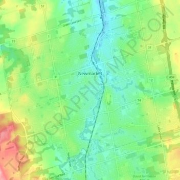
Nom : Carte topographique Newmarket, altitude, relief.
Lieu : Newmarket, York Region, Golden Horseshoe, Ontario, Canada (44.01606 -79.50937 44.08345 -79.41174)
Altitude moyenne : 270 m
Altitude minimum : 230 m
Altitude maximum : 349 m
Autres cartes topographiques
Cliquez sur une carte pour visualiser sa topographie, son altitude et son relief.
Keswick
Canada > Ontario > York Region
Keswick's geographical coordinates are 44.22°N, 79.45°W, and its elevation above sea level is 221m/762 ft. It has a geographical area of 16.25 km² according to Statistics Canada. It is bound on the north by Roches Point, the east by Woodbine Avenue, the south by East Gwillimbury (Ravenshoe Road) and the…
Altitude moyenne : 228 m
Whitchurch-Stouffville Community Park, Vandorf
Canada > Ontario > York Region > Whitchurch-Stouffville
Altitude moyenne : 305 m
East Holland River
Canada > Ontario > York Region > East Gwillimbury > Holland Landing
Altitude moyenne : 223 m
Phyllis Rawlinson Park
Canada > Ontario > York Region > Richmond Hill > Gormley
Altitude moyenne : 252 m
Keswick
Canada > Ontario > York Region
Keswick's geographical coordinates are 44.22°N, 79.45°W, and its elevation above sea level is 221m/762 ft. It has a geographical area of 16.25 km² according to Statistics Canada. It is bound on the north by Roches Point, the east by Woodbine Avenue, the south by East Gwillimbury (Ravenshoe Road) and the…
Altitude moyenne : 228 m