
Faire un don
Équipez-vous pour votre prochaine aventure :
En tant que Partenaire Amazon, ce site perçoit une commission sur les achats éligibles sans surcoût pour vous.
Carte topographique Steg
Cliquez sur la carte pour afficher l’altitude.
Faire un don
Équipez-vous pour votre prochaine aventure :
En tant que Partenaire Amazon, ce site perçoit une commission sur les achats éligibles sans surcoût pour vous.
À propos de cette carte
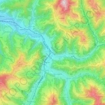
Nom : Carte topographique Steg, altitude, relief.
Lieu : Steg, Fischenthal, Bezirk Hinwil, Zurich, 8496, Switzerland (47.33141 8.91514 47.37141 8.95514)
Altitude moyenne : 836 m
Altitude minimum : 664 m
Altitude maximum : 1 122 m
Faire un don
Équipez-vous pour votre prochaine aventure :
En tant que Partenaire Amazon, ce site perçoit une commission sur les achats éligibles sans surcoût pour vous.
Autres cartes topographiques
Cliquez sur une carte pour visualiser sa topographie, son altitude et son relief.
Wald (ZH)
Switzerland > Zurich > Bezirk Hinwil
At the turn of the 19th and 20th centuries, there were 16 factories in Wald, all of which made their money from textiles. At this time, Wald was also known as the "Manchester of the Canton of Zurich". In the 1860s, the Oberholzer family of factory owners promoted social welfare by establishing workers' housing…
Altitude moyenne : 790 m
Faire un don
Équipez-vous pour votre prochaine aventure :
En tant que Partenaire Amazon, ce site perçoit une commission sur les achats éligibles sans surcoût pour vous.