
Carte topographique Witset
Cliquez sur la carte pour afficher l’altitude.
À propos de cette carte
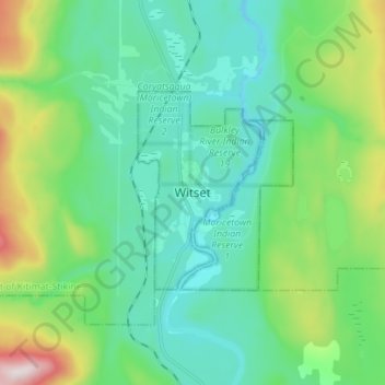
Nom : Carte topographique Witset, altitude, relief.
Lieu : Witset, British Columbia, V0J 3P0, Canada (54.98141 -127.36996 55.06141 -127.28996)
Altitude moyenne : 518 m
Altitude minimum : 347 m
Altitude maximum : 1 087 m
Autres cartes topographiques
Cliquez sur une carte pour visualiser sa topographie, son altitude et son relief.
Vancouver
Canada > British Columbia > Metro Vancouver Regional District
Vancouver, British Columbia, is situated on the Burrard Peninsula, bordered by Burrard Inlet to the north and the Fraser River to the south. The city's topography is a blend of flat and hilly terrains, with elevations ranging from sea level to approximately 152 meters (500 feet) above sea level. The North…
Altitude moyenne : 34 m
Victoria
Canada > British Columbia > Capital Regional District
Victoria, British Columbia, is situated on the southern tip of Vancouver Island, Canada, and boasts a diverse and varied topography. The city is characterized by rolling hills, rugged coastal cliffs, and lush valleys, providing a striking contrast between mountainous terrain and flatland areas. To the north…
Altitude moyenne : 17 m
Kelowna
Canada > British Columbia > Regional District of Central Okanagan
Kelowna is classified as a humid continental climate or an inland oceanic climate per the Köppen climate classification system due to its coldest month having an average temperature slightly above −3.0 °C (26.6 °F) and below 0 °C (32 °F), with dry, hot, sunny summers and cool, cloudy winters, and four…
Altitude moyenne : 704 m
Burnaby
Canada > British Columbia > Metro Vancouver Regional District
Burnaby occupies 98.6 square kilometres (38.1 sq mi) and is located at the geographic centre of the Metro Vancouver Regional District. The regional district's government is located in Burnaby's Metrotown area. Situated between the city of Vancouver on the west and Port Moody, Coquitlam, and New Westminster on…
Altitude moyenne : 59 m
Township of Langley
Canada > British Columbia > Metro Vancouver Regional District
Altitude moyenne : 47 m
Vancouver
Canada > British Columbia > Metro Vancouver Regional District
Vancouver, British Columbia, is situated on the Burrard Peninsula, bordered by Burrard Inlet to the north and the Fraser River to the south. The city's topography is a blend of flat and hilly terrains, with elevations ranging from sea level to approximately 152 meters (500 feet) above sea level. The North…
Altitude moyenne : 34 m
Vancouver Island
The rain shadow effect of the island's mountains, as well as the mountains of Washington's Olympic Peninsula, creates wide variation in precipitation. The west coast is considerably wetter than the east coast. Average annual precipitation ranges from 6,650 mm (262 in) at Hucuktlis Lake on the west coast…
Altitude moyenne : 411 m
Coquitlam
Canada > British Columbia > Metro Vancouver Regional District
Like much of Metro Vancouver, Coquitlam has an oceanic climate (Köppen climate type Cfb), experiencing mild temperatures and high precipitation; warm, dry summers and cool, wet winters. However, compared to most other cities in the area, precipitation is especially heavy in Coquitlam due to its proximity to…
Altitude moyenne : 190 m
West Kelowna
Canada > British Columbia > Regional District of Central Okanagan
Altitude moyenne : 649 m
Princeton
Canada > British Columbia > Regional District of Okanagan-Similkameen
Altitude moyenne : 710 m
Kimberley
Canada > British Columbia > Regional District of East Kootenay
Kimberley has a continental climate with semi-arid influences and heavy moderation from the nearby mountains which tend to block arctic air masses, and produce a rain shadow. Its fairly high elevation counters this effect slightly, as temperatures are somewhat cooler and the town slightly more rainy than it…
Altitude moyenne : 1 216 m
Denman Island
Canada > British Columbia > Comox Valley Regional District > Area A (Baynes Sound)
Altitude moyenne : 36 m
Tsawwassen
Canada > British Columbia > Metro Vancouver Regional District > Delta
Altitude moyenne : 12 m
North Delta
Canada > British Columbia > Metro Vancouver Regional District > Delta
Altitude moyenne : 48 m
Titetown Lake
Canada > British Columbia > Cariboo Regional District > Area I (West Fraser/Nazko)
Altitude moyenne : 864 m
Mayne Island
Canada > British Columbia > Capital Regional District > Southern Gulf Islands Electoral Area > Mayne
Altitude moyenne : 26 m
Gabriola Island
Canada > British Columbia > Regional District of Nanaimo > Area B (DeCourcy/Gabriola/Mudge)
Gabriola is about 14 kilometres (9 mi) long by 4.2 kilometres (2.6 mi) wide on average with a land area of 57.6 square kilometres (22.2 sq mi). The topography varies from flat sandy beaches at sea level to forested hills rising to 160 metres (525 ft) on Stoney Ridge in the centre of the island.
Altitude moyenne : 26 m
Saltspring Island
Canada > British Columbia > Capital Regional District > Salt Spring Island Electoral Area
Altitude moyenne : 72 m
Okanagan Lake
Canada > British Columbia > Regional District of Central Okanagan > Kelowna
Altitude moyenne : 1 194 m
Shuswap Lake
Canada > British Columbia > Columbia-Shuswap Regional District > Area F (Scotch Creek/Seymour Arm)
Altitude moyenne : 1 064 m
Area A (Boston Bar/North Bend/Canyon Alpine)
Canada > British Columbia > Fraser Valley Regional District
Altitude moyenne : 1 260 m
Gulf Islands National Park Reserve
Canada > British Columbia > Capital Regional District > Southern Gulf Islands Electoral Area
Altitude moyenne : 57 m
Chilliwack Lake
Canada > British Columbia > Fraser Valley Regional District > Area E (Chilliwack River Valley)
Altitude moyenne : 1 152 m
Steveston
Canada > British Columbia > Metro Vancouver Regional District > Richmond
Altitude moyenne : 2 m
Joffre Lakes Provincial Park
Canada > British Columbia > Squamish-Lillooet Regional District > Area C (Pemberton Valley/Mount Currie/D'Arcy)
Staying on the trail is important for the preservation of the park environment, and for the safety of hikers. Lower Joffre Lake is a short distance away from the parking lot with no elevation gain. The trail to Middle and Upper Joffre lakes however is more challenging due to the greater elevation gain. Hiking…
Altitude moyenne : 1 911 m
Hernando Island
Canada > British Columbia > qathet Regional District > Area A (Malaspina/Toba)
Altitude moyenne : 23 m
Juan de Fuca Electoral Area
Canada > British Columbia > Capital Regional District
Altitude moyenne : 255 m
Salmon Glacier
Canada > British Columbia > Regional District of Kitimat-Stikine > Stewart
Altitude moyenne : 1 557 m
Prince George
Canada > British Columbia > Regional District of Fraser-Fort George
The area has a humid continental climate (Köppen climate classification Dfb, Trewartha Dclo), but is close to (and once had) a subarctic climate (Dfc) as May and September averages are both close to the 10 °C (50 °F) threshold. Winters are milder than the latitude and elevation might suggest: the January…
Altitude moyenne : 685 m
Penticton
Canada > British Columbia > Regional District of Okanagan-Similkameen
Penticton is located at the geographical coordinates of 49°29′28″N 119°35′19″W / 49.49111°N 119.58861°W / 49.49111; -119.58861 (Penticton) and covers an area of 42.10 km2 (16.25 sq mi), with a maximum north–south distance of 7 km (4.3 mi) wide between the Okanagan Lake to the north…
Altitude moyenne : 702 m
Bowen Island
Canada > British Columbia > Metro Vancouver Regional District > Bowen Island Municipality
Altitude moyenne : 106 m
Kinbasket Lake
Canada > British Columbia > Columbia-Shuswap Regional District
Altitude moyenne : 1 725 m
Gambier Island
Canada > British Columbia > Sunshine Coast Regional District > Area F (West Howe Sound)
Altitude moyenne : 130 m