
Carte topographique Torrance County
Carte interactive
Cliquez sur la carte pour afficher l’altitude.
À propos de cette carte
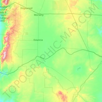
Nom : Carte topographique Torrance County, altitude, relief.
Lieu : Torrance County, New Mexico, United States of America (34.25968 -106.47122 35.04214 -105.29014)
Altitude moyenne : 1 983 m
Altitude minimum : 1 725 m
Altitude maximum : 3 035 m
According to the U.S. Census Bureau, the county has a total area of 3,346 square miles (8,670 km2), of which 3,345 square miles (8,660 km2) is land and 0.9 square miles (2.3 km2) (0.03%) is water. Most of the county is gently-rolling grassland ranging from 6000 to 6200 feet in elevation. The Manzano Mountains rising to 10,098 feet on the western edge of the county provide it with its only significant topographic relief. The Manzano Wilderness area includes the highest part of the mountains. The other notable geographic feature of the county is the series of playas and seasonal lakes centering on Laguna del Perro southeast of Estancia.
Autres cartes topographiques
Cliquez sur une carte pour visualiser sa topographie, son altitude et son relief.
Mora County
United States of America > New Mexico
Mora County, New Mexico, United States of America
Altitude moyenne : 2 150 m
Albuquerque
United States of America > New Mexico > Albuquerque
Albuquerque, Bernalillo County, New Mexico, United States of America
Altitude moyenne : 1 687 m
Doña Ana County
United States of America > New Mexico
Doña Ana County, New Mexico, United States of America
Altitude moyenne : 1 349 m
Tekapo
United States of America > New Mexico > Tekapo
Tekapo, McKinley County, New Mexico, United States of America
Altitude moyenne : 1 900 m