
Carte topographique Albemarle
Carte interactive
Cliquez sur la carte pour afficher l’altitude.
À propos de cette carte
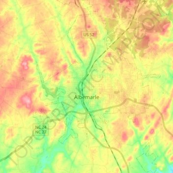
Nom : Carte topographique Albemarle, altitude, relief.
Altitude moyenne : 166 m
Altitude minimum : 101 m
Altitude maximum : 229 m
The city is centered on the junction of U.S. Route 52 and the duplexed NC-24/27 in the Piedmont Region of North Carolina. Its topography is characterized by rolling, eroded hills, deciduous forests, and fast-running, narrow, shallow streams that feed the Yadkin/Pee Dee River Basin. Little Long Creek and Town Creek are the major non-seasonal streams through Albemarle; both flow generally southward into the Long and Big Bear Creek Sub-basin.
Autres cartes topographiques
Cliquez sur une carte pour visualiser sa topographie, son altitude et son relief.
Norwood
United States > North Carolina > Stanly County
Norwood, Stanly County, North Carolina, United States
Altitude moyenne : 112 m
Forest Drive
United States > North Carolina > Stanly County > Albemarle > Forest Drive
Forest Drive, Albemarle, Stanly County, North Carolina, 28001, United States
Altitude moyenne : 166 m