
Carte topographique Alvor
Carte interactive
Cliquez sur la carte pour afficher l’altitude.
À propos de cette carte
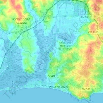
Nom : Carte topographique Alvor, altitude, relief.
Lieu : Alvor, Portimão, Faro, Portugal (37.11415 -8.62157 37.17064 -8.56067)
Altitude moyenne : 15 m
Altitude minimum : -3 m
Altitude maximum : 62 m
The Prince Regent ordered, in the name of Manuel of Portugal, the elevation of Alvor to vila (town) on 28 February 1495, which was confirmed in a secondary diploma on 28 December 1498.
Autres cartes topographiques
Cliquez sur une carte pour visualiser sa topographie, son altitude et son relief.
Mexilhoeira Grande
Mexilhoeira Grande, Portimão, Faro, 8500-130, Portugal
Altitude moyenne : 28 m