
Carte topographique District de Chitrâl
Carte interactive
Cliquez sur la carte pour afficher l’altitude.
À propos de cette carte
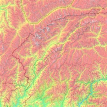
Nom : Carte topographique District de Chitrâl, altitude, relief.
Altitude moyenne : 3 729 m
Altitude minimum : 841 m
Altitude maximum : 7 533 m
Le territoire du Chitral est très montagneux. une partie des monts du Pamir s'y élèvent. Le pic le plus élevé est le Tirich Mir, qui avec ses 7 708 mètres d'altitude est le plus haut sommet de l'Hindou Kouch, et se dresse au nord du territoire du district.
Autres cartes topographiques
Cliquez sur une carte pour visualiser sa topographie, son altitude et son relief.
Peshawar
Pakistan > Khyber Pakhtunkhwa > Peshawar
Peshawar, Peshāwar District, Khyber Pakhtunkhwa, Pakistan
Altitude moyenne : 359 m
Istor-o-Nal
Istor-o-Nal, Chitrāl District, Khyber Pakhtunkhwa, Pakistan
Altitude moyenne : 6 853 m
Khyber Pakhtunkhwa
Khyber Pakhtunkhwa, Pakistan
Altitude moyenne : 2 135 m
Nowshak
Nowshak, Chitrāl District, Khyber Pakhtunkhwa, Pakistan
Altitude moyenne : 6 863 m
Tirich Mir
Tirich Mir, Chitrāl District, Khyber Pakhtunkhwa, Pakistan
Altitude moyenne : 6 886 m