
Carte topographique Frammersbach
Cliquez sur la carte pour afficher l’altitude.
Frammersbach
Der staatlich anerkannte Erholungsort liegt zwischen Würzburg und Aschaffenburg mitten im Naturpark Spessart. Der Hauptort liegt am Zulauf des Laubersbachs zur Lohr; Habichsthal in geographisch getrennter kleiner Gemarkung etwa fünf Kilometer westlich davon im kurzen Mühlbach-Seitental des erst unterhalb der Gemeindegrenzen in die Lohr fließenden Aubachs. Der mit 460 m ü. NHN topographisch höchste Punkt der Gemeinde (Lage)50.053669.38531 befindet sich westlich von Habichsthal am Osthang des Sandkopfes, der niedrigste auf 199 m ü. NHN an der Lohr (Lage)50.050039.50333.
À propos de cette carte
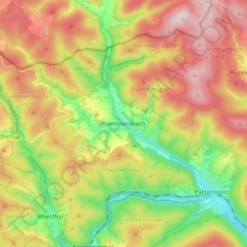
Nom : Carte topographique Frammersbach, altitude, relief.
Altitude moyenne : 363 m
Altitude minimum : 174 m
Altitude maximum : 572 m
Autres cartes topographiques
Cliquez sur une carte pour visualiser sa topographie, son altitude et son relief.
Neustadt a. Main
Deutschland > Bayern > Landkreis Main-Spessart > Neustadt a.Main
Altitude moyenne : 299 m
Marktheidenfeld
Deutschland > Bayern > Landkreis Main-Spessart > Marktheidenfeld > Marktheidenfeld
Altitude moyenne : 236 m
Rengersbrunn
Deutschland > Bayern > Landkreis Main-Spessart > Fellen > Rengersbrunn
Altitude moyenne : 437 m
Gut Ebenroth
Deutschland > Bayern > Landkreis Main-Spessart > Arnstein > Reuchelheim
Altitude moyenne : 297 m
Brückenfundamentloch Reichsautobahn Strecke 46, Fulda-Würzburg
Deutschland > Bayern > Landkreis Main-Spessart > Gemünden am Main > Seifriedsburg
Altitude moyenne : 307 m
Eichenfürst
Deutschland > Bayern > Landkreis Main-Spessart > Marktheidenfeld > Altfeld
Altitude moyenne : 253 m
Hasberg
Deutschland > Bayern > Landkreis Main-Spessart > Ruppertshüttener Forst
Altitude moyenne : 417 m
Bayerische Schanz (507,9)
Deutschland > Bayern > Landkreis Main-Spessart > Lohr am Main
Altitude moyenne : 491 m
Seifriedsburg
Deutschland > Bayern > Landkreis Main-Spessart > Gemünden am Main
Altitude moyenne : 289 m
Langenprozelten
Deutschland > Bayern > Landkreis Main-Spessart > Gemünden am Main
Altitude moyenne : 246 m
Arnstein
Deutschland > Bayern > Landkreis Main-Spessart > Arnstein > Arnstein
Altitude moyenne : 279 m
Adelsberg
Deutschland > Bayern > Landkreis Main-Spessart > Gemünden am Main > Adelsberg
Altitude moyenne : 246 m