
Carte topographique Solok
Carte interactive
Cliquez sur la carte pour afficher l’altitude.
À propos de cette carte
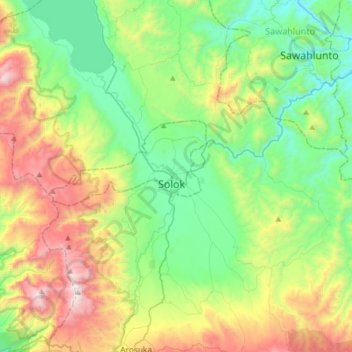
Nom : Carte topographique Solok, altitude, relief.
Lieu : Solok, West Sumatra, Indonesia (-0.95222 100.49733 -0.63222 100.81733)
Altitude moyenne : 735 m
Altitude minimum : 194 m
Altitude maximum : 1 878 m
Solok (means valley) is a city in West Sumatra, Indonesia. Its motto is Kota Beras, abbreviation from "Bersih, Elok, Rapi, Aman dan Sejahtera". It has an area of 57.64 km² (0.14 percent of the area of West Sumatra) and a population of 69,776 people in 2018. Solok topography varies between the plains and hilly with a height of 390 m above sea level. There are three tributaries that cross Solok, namely Batang Lembang, Batang Gawan, and Batang Air Binguang.