
Carte topographique Kekri
Carte interactive
Cliquez sur la carte pour afficher l’altitude.
À propos de cette carte
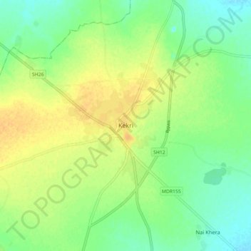
Nom : Carte topographique Kekri, altitude, relief.
Lieu : Kekri, Kekri Tehsil, Ajmer District, Rajasthan, 305404, India (25.93421 75.11457 26.01421 75.19457)
Altitude moyenne : 353 m
Altitude minimum : 339 m
Altitude maximum : 366 m
Autres cartes topographiques
Cliquez sur une carte pour visualiser sa topographie, son altitude et son relief.
Baghera
India > Rajasthan > Kekri Tehsil
Baghera, Kekri Tehsil, Ajmer District, Rajasthan, 305415, India
Altitude moyenne : 321 m