
Carte topographique Piotrkowice
Carte interactive
Cliquez sur la carte pour afficher l’altitude.
À propos de cette carte
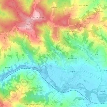
Nom : Carte topographique Piotrkowice, altitude, relief.
Altitude moyenne : 286 m
Altitude minimum : 211 m
Altitude maximum : 398 m
Autres cartes topographiques
Cliquez sur une carte pour visualiser sa topographie, son altitude et son relief.
Siedlec
Poland > Lesser Poland Voivodeship > Tarnów County
Siedlec, gmina Radłów, Tarnów County, Lesser Poland Voivodeship, Poland
Altitude moyenne : 184 m
Dwudniaki
Poland > Lesser Poland Voivodeship > Tarnów County > Wierzchosławice
Dwudniaki, Wierzchosławice, gmina Wierzchosławice, Tarnów County, Lesser Poland Voivodeship, 33-122, Poland
Altitude moyenne : 192 m
Skała
Poland > Lesser Poland Voivodeship > Tarnów County > Koszyce Małe
Skała, Koszyce Małe, gmina Tarnów, Tarnów County, Lesser Poland Voivodeship, 33-111, Poland
Altitude moyenne : 231 m
Żabno
Poland > Lesser Poland Voivodeship > Tarnów County
Żabno, gmina Żabno, Tarnów County, Lesser Poland Voivodeship, 33-240, Poland
Altitude moyenne : 186 m