
Carte topographique 中心村
Carte interactive
Cliquez sur la carte pour afficher l’altitude.
À propos de cette carte
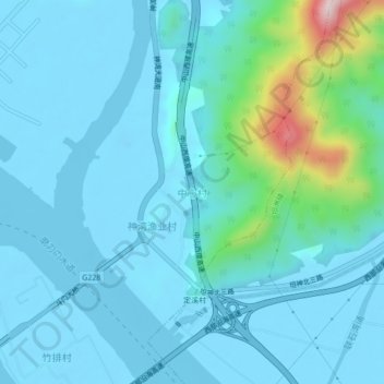
Nom : Carte topographique 中心村, altitude, relief.
Lieu : 中心村, Zhongshan, Guangdong Province, China (22.25852 113.34286 22.29852 113.38286)
Altitude moyenne : 55 m
Altitude minimum : -14 m
Altitude maximum : 432 m
Autres cartes topographiques
Cliquez sur une carte pour visualiser sa topographie, son altitude et son relief.
Longxuecun
China > Guangdong Province > Zhongshan
Longxuecun, Zhongshan, Guangdong Province, China
Altitude moyenne : 6 m
Zhongshan
China > Guangdong Province > Zhongshan
Zhongshan, Guangdong Province, 528403, China
Altitude moyenne : 26 m