
Carte topographique Praag
Carte interactive
Cliquez sur la carte pour afficher l’altitude.
À propos de cette carte
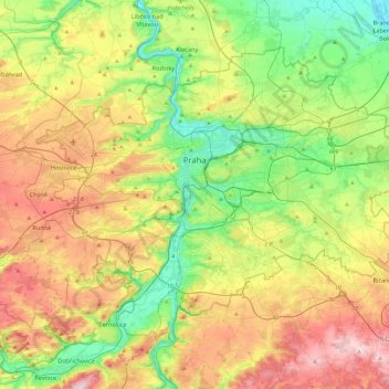
Nom : Carte topographique Praag, altitude, relief.
Lieu : Praag, Praha, Tsjechië (49.94190 14.22444 50.17743 14.70679)
Altitude moyenne : 300 m
Altitude minimum : 167 m
Altitude maximum : 508 m
Ook het Dansende Huis is een gebouw dat opvalt. Niet vanwege zijn hoogte, maar vanwege de deconstructivistische bouwstijl. Het gebouw staat aan de Moldau en werd geopend in 1996.
Autres cartes topographiques
Cliquez sur une carte pour visualiser sa topographie, son altitude et son relief.