
Carte topographique Newton
Carte interactive
Cliquez sur la carte pour afficher l’altitude.
À propos de cette carte
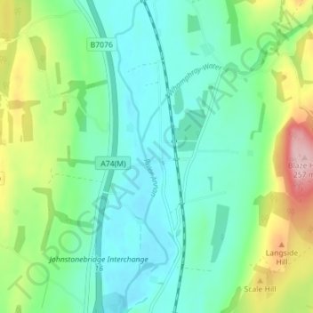
Nom : Carte topographique Newton, altitude, relief.
Altitude moyenne : 117 m
Altitude minimum : 63 m
Altitude maximum : 261 m
Autres cartes topographiques
Cliquez sur une carte pour visualiser sa topographie, son altitude et son relief.
Kirkton
United Kingdom > Scotland > Dumfries and Galloway
Kirkton, Dumfries and Galloway, Scotland, DG1 1WD, United Kingdom
Altitude moyenne : 24 m
Beattock
United Kingdom > Scotland > Dumfries and Galloway
Beattock, Dumfries and Galloway, Scotland, DG10 9RB, United Kingdom
Altitude moyenne : 144 m
Calfield
United Kingdom > Scotland > Dumfries and Galloway > Langholm > Becks
Calfield, Becks, Langholm, Dumfries and Galloway, Scotland, DG13 0LP, United Kingdom
Altitude moyenne : 204 m
Closeburn
United Kingdom > Scotland > Dumfries and Galloway
Closeburn, Dumfries and Galloway, Scotland, DG3 5HT, United Kingdom
Altitude moyenne : 81 m