
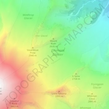
Carte topographique Emmons Glacier
Carte interactive
Cliquez sur la carte pour afficher l’altitude.
À propos de cette carte
Nom : Carte topographique Emmons Glacier, altitude, relief.
Altitude moyenne : 2 577 m
Altitude minimum : 1 503 m
Altitude maximum : 4 317 m
Autres cartes topographiques
Cliquez sur une carte pour visualiser sa topographie, son altitude et son relief.
Camano Island
Camano Island, Camano, Island County, Washington, 98282, USA
Altitude moyenne : 27 m
Maple Valley
USA > Washington > Maple Valley
Maple Valley, King County, Washington, 98038, USA
Altitude moyenne : 160 m
Entiat Glacier
Entiat Glacier, Mount Maude Summit Approach, Chelan County, Washington, USA
Altitude moyenne : 2 145 m
Montesano
USA > Washington > Montesano
Montesano, Grays Harbor County, Washington, USA
Altitude moyenne : 65 m
Sulphide Glacier
Sulphide Glacier, Sulfide Glacier Route, Whatcom County, Washington, USA
Altitude moyenne : 1 815 m
Fairchild Glacier
Fairchild Glacier, Mount Carrie Way Trail, Clallam County, Washington, USA
Altitude moyenne : 1 611 m
Cameron Glaciers
Cameron Glaciers, Main Fork Dosewallips River Trail, Jefferson County, Washington, USA
Altitude moyenne : 1 796 m
Wilson Glacier
USA > Washington > Paradise
Wilson Glacier, Camp Muir Route, Paradise, Pierce County, Washington, USA
Altitude moyenne : 2 603 m
Kautz Glacier
USA > Washington > Paradise
Kautz Glacier, Van Trump Trail, Paradise, Pierce County, Washington, USA
Altitude moyenne : 2 726 m
Winthrop Glacier
Winthrop Glacier, Glacier Basin Trail, Pierce County, Washington, USA
Altitude moyenne : 2 380 m
So-Bahli-Alhi Glacier
USA > Washington > White Horse
So-Bahli-Alhi Glacier, Neiderprum Trail, White Horse, Snohomish County, Washington, USA
Altitude moyenne : 1 382 m
Yawning Glacier
Yawning Glacier, Ptarmigan Traverse, Chelan County, Washington, USA
Altitude moyenne : 1 712 m
Mount Shuksan
Mount Shuksan, Whatcom County, Washington, USA
Altitude moyenne : 2 126 m
Terror Glacier
Terror Glacier, Whatcom County, Washington, USA
Altitude moyenne : 1 866 m
Lyall Glacier
Lyall Glacier, Maple Pass Trail, Chelan County, Washington, USA
Altitude moyenne : 1 932 m
Suiattle Glacier
Suiattle Glacier, Foam Creek Trail, Chelan County, Washington, USA
Altitude moyenne : 2 153 m
Sherpa Glacier
Sherpa Glacier, Horseshoe Lake Trail, Chelan County, Washington, USA
Altitude moyenne : 2 069 m
Fryingpan Glacier
Fryingpan Glacier, Wonderland Trail, Pierce County, Washington, USA
Altitude moyenne : 2 386 m
Enumclaw
USA > Washington > Enumclaw
Enumclaw, King County, Washington, 98022, USA
Altitude moyenne : 238 m
Quien Sabe Glacier
Quien Sabe Glacier, Sahale Arm Trail, Skagit County, Washington, USA
Altitude moyenne : 2 143 m
Sahale Glacier
Sahale Glacier, Sahale Arm Trail, Skagit County, Washington, USA
Altitude moyenne : 2 062 m
Stuart Glacier
Stuart Glacier, Horseshoe Lake Trail, Chelan County, Washington, USA
Altitude moyenne : 2 098 m
Company Glacier
USA > Washington > Holden Village
Company Glacier, Cloudy Pass Trail #1256, Holden Village, Chelan County, Washington, USA
Altitude moyenne : 2 164 m
Spire Glacier
Spire Glacier, Ptarmigan Traverse, Chelan County, Washington, USA
Altitude moyenne : 1 946 m
Jeffers Glacier
Jeffers Glacier, Humes Glacier Route, Jefferson County, Washington, USA
Altitude moyenne : 1 656 m
Puyallup Glacier
Puyallup Glacier, Wonderland Trail, Pierce County, Washington, USA
Altitude moyenne : 2 475 m
Olympic Mountains
Olympic Mountains, Jefferson County, Washington, 98305, USA
Altitude moyenne : 511 m
No Name Glacier
No Name Glacier, Hadley Peak Route, Whatcom County, Washington, USA
Altitude moyenne : 1 984 m
South Cascade Glacier
South Cascade Glacier, Ptarmigan Traverse, Chelan County, Washington, USA
Altitude moyenne : 1 972 m
Honeycomb Glacier
Honeycomb Glacier, Snohomish County, Washington, USA
Altitude moyenne : 2 106 m
Carrie Glacier
Carrie Glacier, Bailey Range Way Trail, Jefferson County, Washington, USA
Altitude moyenne : 1 725 m
Tahoma Glacier
Tahoma Glacier, Wonderland Trail, Pierce County, Washington, USA
Altitude moyenne : 2 517 m
Nisqually Glacier
USA > Washington > Paradise
Nisqually Glacier, Camp Muir Route, Paradise, Pierce County, Washington, USA
Altitude moyenne : 2 711 m
Snow Creek Glacier
Snow Creek Glacier, Little Annapurna summit trail, Chelan County, Washington, USA
Altitude moyenne : 2 225 m
Dusty Glacier
Dusty Glacier, Pacific Crest Trail, Snohomish County, Washington, USA
Altitude moyenne : 2 371 m
Whitman Glacier
Whitman Glacier, Wonderland Trail, Pierce County, Washington, USA
Altitude moyenne : 2 519 m
Glacier Peak
Glacier Peak, Snohomish County, Washington, USA
Altitude moyenne : 2 653 m
Success Glacier
USA > Washington > Paradise
Success Glacier, Van Trump Trail, Paradise, Pierce County, Washington, USA
Altitude moyenne : 2 784 m
Cowlitz Glacier
USA > Washington > Paradise
Cowlitz Glacier, Camp Muir Route, Paradise, Pierce County, Washington, USA
Altitude moyenne : 2 371 m
Sholes Glacier
Sholes Glacier, Park Glacier Route, Whatcom County, Washington, USA
Altitude moyenne : 1 702 m
Banded Glacier
Banded Glacier, Fisher Creek Trail, Skagit County, Washington, USA
Altitude moyenne : 2 158 m
Cascade Range
Cascade Range, Skamania County, Washington, USA
Altitude moyenne : 690 m
Paradise Glacier
USA > Washington > Paradise
Paradise Glacier, Camp Muir Route, Paradise, Pierce County, Washington, USA
Altitude moyenne : 2 256 m
Lillian Glacier
Lillian Glacier, Cameron Pass Trail, Jefferson County, Washington, USA
Altitude moyenne : 1 738 m
Henry M. Jackson Wilderness
Henry M. Jackson Wilderness, Cady Creek Trail, Chelan County, Washington, USA
Altitude moyenne : 1 307 m