
Carte topographique South Ayrshire
Carte interactive
Cliquez sur la carte pour afficher l’altitude.
À propos de cette carte
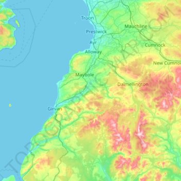
Nom : Carte topographique South Ayrshire, altitude, relief.
Lieu : South Ayrshire, Schotland, VK (54.99764 -5.06097 55.60187 -4.39886)
Altitude moyenne : 151 m
Altitude minimum : 0 m
Altitude maximum : 834 m
Autres cartes topographiques
Cliquez sur une carte pour visualiser sa topographie, son altitude et son relief.
Old Polmont
VK > Schotland > Old Polmont
Old Polmont, Falkirk, Schotland, FK2 0XZ, VK
Altitude moyenne : 37 m
Greenbraehead
VK > Schotland > Greenbraehead
Greenbraehead, Scottish Borders, Schotland, TD9 9SW, VK
Altitude moyenne : 187 m
Carnoustie
VK > Schotland > Carnoustie
Carnoustie, Angus, Schotland, DD7 6AE, VK
Altitude moyenne : 24 m
Loch Lubnaig
VK > Schotland > Ardchullarie More
Loch Lubnaig, A84, Ardchullarie More, Stirling, Schotland, FK17 8HF, VK
Altitude moyenne : 382 m
Inverasdale
VK > Schotland > Inverasdale
Inverasdale, Highland, Schotland, IV22 2LW, VK
Altitude moyenne : 54 m
Loch Lomond
Loch Lomond, A82, Tom Na Glas, Inverbeg, Argyll and Bute, Schotland, G83 8PD, VK
Altitude moyenne : 240 m
Fort Augustus
VK > Schotland > Fort Augustus
Fort Augustus, Highland, Schotland, PH32 4AY, VK
Altitude moyenne : 115 m