
Carte topographique Sau Mau Ping Memorial Park
Carte interactive
Cliquez sur la carte pour afficher l’altitude.
À propos de cette carte
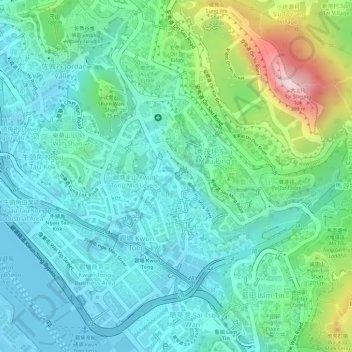
Nom : Carte topographique Sau Mau Ping Memorial Park, altitude, relief.
Altitude moyenne : 102 m
Altitude minimum : -7 m
Altitude maximum : 399 m
Autres cartes topographiques
Cliquez sur une carte pour visualiser sa topographie, son altitude et son relief.
Kwun Tong Promenade
Kwun Tong Promenade, 80, Kwun Tong, Sau Mau Ping, Kwun Tong District, Hong Kong, PRC
Altitude moyenne : 21 m