
Carte topographique Tolmezzo
Carte interactive
Cliquez sur la carte pour afficher l’altitude.
À propos de cette carte
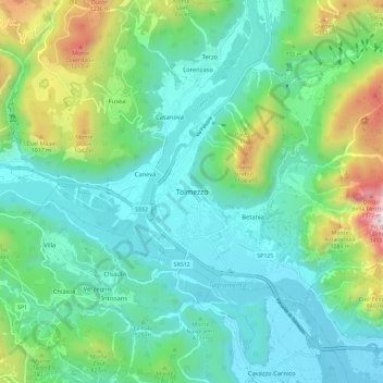
Nom : Carte topographique Tolmezzo, altitude, relief.
Lieu : Tolmezzo, Udine, Friuli-Venezia Giulia, 33028, Italy (46.36537 12.97584 46.44537 13.05584)
Altitude moyenne : 563 m
Altitude minimum : 263 m
Altitude maximum : 1 532 m
Tolmezzo is located at the foot of the Strabut Mountain, between the Tagliamento River and the Bût stream. Nearby is the Mount Amariana, elevation 1,906 metres (6,253 ft). The commune also includes the five frazioni of Cadunea (Friulian: Cjadugnee), Caneva (Cjanive), Casanova (Cjasegnove), Fusea (Fusee), Illegio (Dieç), Imponzo (Dimponç).