
Faire un don
Équipez-vous pour votre prochaine aventure :
En tant que Partenaire Amazon, ce site perçoit une commission sur les achats éligibles sans surcoût pour vous.
Carte topographique Konnagar
Cliquez sur la carte pour afficher l’altitude.
Faire un don
Équipez-vous pour votre prochaine aventure :
En tant que Partenaire Amazon, ce site perçoit une commission sur les achats éligibles sans surcoût pour vous.
Konnagar
Konnagar is located at 22°42′12″N 88°19′07″E / 22.7032°N 88.3185°E / 22.7032; 88.3185. It has an average elevation of 14 metres (45 feet). Konnagar is positioned between Rishra and Hind Motor on the Howrah-Bardhaman main line and Grand Trunk Road. It is located on the west bank of the River Hooghly. Its approximate area is 4.32 km2.
Faire un don
Équipez-vous pour votre prochaine aventure :
En tant que Partenaire Amazon, ce site perçoit une commission sur les achats éligibles sans surcoût pour vous.
À propos de cette carte
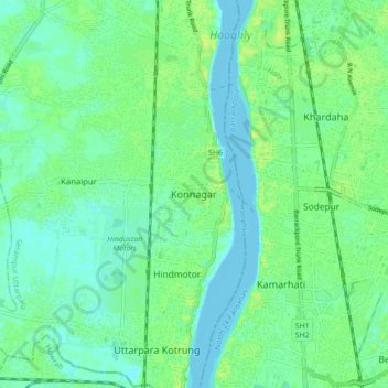
Nom : Carte topographique Konnagar, altitude, relief.
Altitude moyenne : 6 m
Altitude minimum : -2 m
Altitude maximum : 14 m
Faire un don
Équipez-vous pour votre prochaine aventure :
En tant que Partenaire Amazon, ce site perçoit une commission sur les achats éligibles sans surcoût pour vous.