
Carte topographique Mpraeso
Carte interactive
Cliquez sur la carte pour afficher l’altitude.
À propos de cette carte
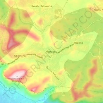
Nom : Carte topographique Mpraeso, altitude, relief.
Lieu : Mpraeso, Kwahu South District, Eastern Region, Ghana (6.55661 -0.77339 6.63661 -0.69339)
Altitude moyenne : 486 m
Altitude minimum : 225 m
Altitude maximum : 768 m
Mpraeso is a town and the capital of Kwahu South district, a district in the Eastern Region of south Ghana, located at an altitude of 367 m on the Kwahu Plateau, which forms the south-west boundary of Lake Volta. Mpraeso has a 2013 settlement population of 11,190 people.