
Carte topographique Municipality of Ancient Olympia
Carte interactive
Cliquez sur la carte pour afficher l’altitude.
À propos de cette carte
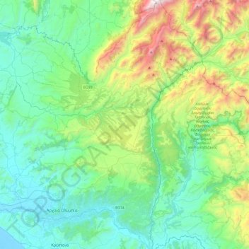
Nom : Carte topographique Municipality of Ancient Olympia, altitude, relief.
Altitude moyenne : 488 m
Altitude minimum : -6 m
Altitude maximum : 2 112 m
Autres cartes topographiques
Cliquez sur une carte pour visualiser sa topographie, son altitude et son relief.
Ancient Olympia
Greece > Peloponnese, Western Greece and the Ionian > Elis Regional Unit
Ancient Olympia, Municipality of Ancient Olympia, Elis Regional Unit, Western Greece, Peloponnese, Western Greece and the Ionian, 270 65, Greece
Altitude moyenne : 99 m
Zacharo
Greece > Peloponnese, Western Greece and the Ionian > Elis Regional Unit > Zacharo Municipal Unit
Zacharo, Zacharo Municipal Unit, Municipality of Zacharo, Elis Regional Unit, Western Greece, Peloponnese, Western Greece and the Ionian, 270 54, Greece
Altitude moyenne : 85 m