
Carte topographique Hampden
Carte interactive
Cliquez sur la carte pour afficher l’altitude.
Hampden
According to the United States Census Bureau, the town has a total area of 19.6 square miles (51 km2), of which 19.6 square miles (51 km2) is land and 0.05% is water. Hampden is located at the eastern edge of the Connecticut River Valley. Hills rise up to over 1,000 feet (300 m) above sea level, from the valley elevation of 150 to 250 feet (46 to 76 m). The highest peaks are Pine Mt. and Rattlesnake Peak, both at 1,070 feet (330 m). The town has no large bodies of water, but has several brooks which eventually drain into the Connecticut River.
À propos de cette carte
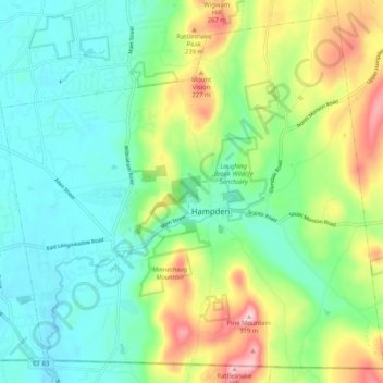
Nom : Carte topographique Hampden, altitude, relief.
Lieu : Hampden, Hampden County, Massachusetts, 01036, United States (42.03270 -72.46993 42.10313 -72.36699)
Altitude moyenne : 143 m
Altitude minimum : 60 m
Altitude maximum : 328 m