
Carte topographique Taytay
Carte interactive
Cliquez sur la carte pour afficher l’altitude.
À propos de cette carte
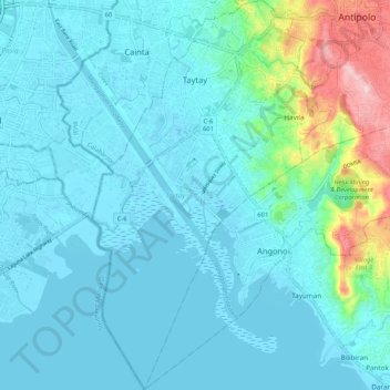
Nom : Carte topographique Taytay, altitude, relief.
Lieu : Taytay, Rizal, Calabarzon, Philippines (14.48945 121.10408 14.59150 121.16894)
Altitude moyenne : 37 m
Altitude minimum : -3 m
Altitude maximum : 249 m
The shape of Taytay is rectangular – trapezoidal with gently hilly rolling terrain on its eastern side while relatively flat on its south-western side, including the poblacion. The municipality's highest elevation ranges from 200 to 255 meters which is situated along the inner north-eastern hills of Barangay Dolores, alongside the Antipolo Boundary. Its lowest points are from 5 to 20 meters along the southern portion of Barangay San Juan and Muzon towards Laguna Lake.
Autres cartes topographiques
Cliquez sur une carte pour visualiser sa topographie, son altitude et son relief.
San Guillermo
Philippines > Rizal > Morong
San Guillermo, Morong, Rizal, Calabarzon, 1960, Philippines
Altitude moyenne : 75 m
Santa Ana
Philippines > Rizal > Santa Ana
Santa Ana, Taytay, Rizal, Calabarzon, 1920, Philippines
Altitude moyenne : 13 m
San Juan
Philippines > Rizal > San Juan
San Juan, Cainta, Rizal, Calabarzon, 190, Philippines
Altitude moyenne : 13 m